Pitfalls and Potentials of Microclimate Simulations in Urban Planning
Publication: Journal of Urban Planning and Development
Volume 149, Issue 4
Abstract
In the face of climate change and rising mean global temperature, urban planning is required to transform cities into resilient living areas for present and future generations. Within this task, microclimate simulation models are an important tool to assess the impact of nature-based solutions (NBSs), building morphology, design of urban quarters, and other measures on the local microclimate. As simulation tools are open to be applied by different user groups, the utilization of the software is often kept as easy as possible. This seeming simplicity bears the risk for users to fall into traps during the model configuration, interpretation of results, or not making use of the full potential of simulations. While scientific literature mainly describes successful application of case studies, it does not cover potential misapplication and related consequences. The present study contributes to closing this research gap and supports the urban planning community with a selection of pitfalls in the model setup and interpretation of results. Clear examples of wrong configuration of wind direction, inaccurate evaluation of mean radiant temperature (MRT), and improper selection of performance indicators are presented by the means of sensitivity experiments and case studies with the modeling software ENVI-Met. The prevailing study demonstrates why MRT values are not suitable to explain effects of NBS during nighttime and contrasts the effects of façade greening on air temperature (0.85°C) with building surface temperature (6.1°C or even 27.5°C with substrate layer). In addition, it highlights the potentials of the multitude of possible performance indicators of microclimate simulations. The selection of avoidable mistakes in the assessment of the local microclimate supports users of microclimate models to promote effective and impactful climate adaption and mitigation measures in urban planning.
Introduction
In the context of climate change, urban areas are facing numerous transformation challenges. A frequently discussed topic is the local impact of global warming in the form of the urban heat island effect (UHIE), affecting the quality of life for city dwellers. Main causes include sealing of permeable soil, construction materials with different heat storage capacities than natural ones (Singh et al. 2020; Sharifi and Lehmann 2014), urban geometry causing reduced ventilation through wind flow (Gu et al. 2020; Arkon and Özkol 2014), and anthropogenic heat production (Shahmohamadi et al. 2011). These factors are further enhanced through reduced available vegetation and thus a lack of natural shade, reduced cooling through evapotranspiration, and less storage of rainwater (Bay 2006). Urban structures (e.g., street canyons as U-shaped areas between buildings) contribute to heat storage in cities through trapping of longwave radiation attributed to reduced sky view factors (SVFs) (Qiao et al. 2013; Singh et al. 2020) and subsequently higher air temperatures at night. Nevertheless, buildings also provide shaded areas during the day, enhancing thermal comfort and reducing heating of pavement and road surfaces through direct solar radiation (Zhang et al. 2022; Vuckovic et al. 2019). The pleasant effect of shading allows pedestrians to move to more comfortable spaces in the street with lower mean radiant temperature (MRT) on summer days with stressful climatic situations (Ali-Toudert and Mayer 2006).
According to United Nations projections, almost two-thirds of the world’s population will live in urban areas by 2050 highlighting the urgency to improve urban microclimate (United Nations, Department of Economic and Social Affairs, Population Division 2019). With this view of growing population and rising temperatures, urban planning needs to transform cities in a way that they are both livable and comfortable for their citizens but also resilient to climate and global challenges. Planners are encouraged to set the right levers to keep outdoor spaces enjoyable and ensure thermal comfort in urban spaces. To support the urban planning community in the latter, microclimate simulations became an important tool in the assessment of potential measures in urban planning projects over the last decade (Albdour and Baranyai 2019).
Numerous studies demonstrate potential applications of microclimate simulations by focusing on different aspects of the impact of urban planning on local climate, such as urban densification (Loibl et al. 2021), urban morphology (Zhang et al. 2022; Pacifici 2019), climatic evaluation of urban design (Mauree et al. 2018), evaluation of mitigation effects of UHI (Ambrosini et al. 2014), cooling strategies (Görgen and Rossi-Schwarzenbeck 2021), or building energy modeling (Salvati and Kolokotroni 2019), thereby taking into account different aspects such as thermal comfort indices, temperature and radiation parameters, heat storage and other characteristics of construction materials, and effects of nature-based solutions (NBSs). Assessment of impacts of NBSs in urban areas plays an important role in encouraging the implementation of effective climate mitigation and adaptation strategies. Comparison and verification of microclimate model data with observations from different field experiments prove the quality of the simulated data (Ouyang et al. 2022; Sinsel et al. 2022; Salata et al. 2016; Maggiotto et al. 2014; Yang et al. 2013).
However, in the comprehensive collection of case studies, proper setup, configuration, and interpretation of microclimate simulations has not been of prior concern yet. Easy-to-use simulation software (e.g., ENVI-Met) can be quickly applied by different user groups without a scientific background in meteorology or climatology and might suggest a false sense of correctness and certainty of results. Its high user-friendliness bears the risk of hiding pitfalls oversimplifying simulation results and might lack in communication of prerequisites and conditions for which results are calculated and thus valid. The multitude of model related outputs and performance indicators further complicates selection and proper interpretation of model results. During the analysis of different output parameters, ambivalent outcomes might be revealed, which need to be investigated in detail to get a holistic view of the analyzed situation and identify potential shortcomings. Misinterpretations due to inaccurately used output parameters, sloppy configuration of initial model setup, or missing knowledge about the capabilities, represented physics, and calculation processes of the used model can lead to wrong conclusions. Therefore, this paper aims to support the urban planning community and users of microclimate models in the understanding and proper application of microclimate simulations. It will encourage making use of the enormous potentials of the available tools and simultaneously prevent stumbling into pitfalls and hidden traps. To achieve these objectives, a theoretical background on the calculation and interpretation of the widely used indicators of air temperature (AT), mean radiant temperature (MRT), and building surface temperature (BST) is presented in the methodology section. Based on the provided theory and sensitivity experiments, several pitfalls in the modeling and interpretation of results are further illustrated together with potentials of microclimate simulations as an impact evaluation tool in urban planning projects. These kinds of models can help urban planners to improve their concepts in a time-efficient and cost-effective manner if applied correctly. Some municipalities even request microclimate simulations for building projects in town planning agreements.
Within the current research project GreenDeal4Real supporting this study, the focus is particularly on improving thermal comfort in a mixed-used development area in the 22nd district of Vienna. In addition to the assessment and evaluation of the mentioned microclimatic indicators for innovative roof and façade greening methods, the project aims at the implementation of green infrastructure from the very beginning of a planning process together with different stakeholders (architects, real estate developers, municipal authorities, etc.,) to optimize thermal comfort for future residents.
Methodology
The microclimate model ENVI-Met is chosen to demonstrate a selection of pitfalls and potentials of microclimate simulations. It provides a range of model output data for different applications in urban planning. The scope of potential research areas includes thermal comfort, UHIE, impact of vegetation and NBS (trees, green walls/roofs, etc.,), materials and albedo, building physics, water bodies, street canyon geometry and orientation, wind analysis, optimum building shape and height, heat sinks, design of urban quarters (building arrangement), natural ventilation, energy demand, pollutant dispersion, and many more (Albdour and Baranyai 2019; Mosteiro-Romero et al. 2020; ENVI-Met 2022). Case studies with ENVI-Met predominantly deal with the topic of heat and thus apply autochthonous weather conditions during summer (low wind, no clouds) for simulations.
ENVI-Met is a three-dimensional model, designed for microscale simulations with a horizontal resolution from 0.5 to 10 m and a time frame of 24–48 h with a time step of 1–5 s. Using an atmospheric model, soil model, and vegetation model, ENVI-Met allows to analyze small-scale interactions between buildings, surfaces, and plants. It provides, for example, high-resolution modeling of all radiative fluxes; transpiration, evaporation, and sensible heat flux from the vegetation into the air; dynamic surface temperature and wall temperature calculation for each façade and roof element; support of wall roof greening systems; and calculates MRT, predicted mean vote (PMV), physiological equivalent temperature (PET), or universal thermal climate index (UTCI). Initial and boundary conditions of temperature, humidity, wind speed (recommended with min. 1 m/s and max. 5 m/s), wind direction, and cloud cover can be forced (ENVI-Met 2022). For the simulations in this study, V5.0.2 with activated integrated view sphere (IVS), the six-directional MRT calculation approach, and activated advanced canopy radiation transfer module (ACRT) is used.
In this section, the theoretical background of selected parameters (AT, MRT, BST) is compiled together with their implementation in ENVI-Met, followed by the description of the experiment domain and sensitivity experiments to illustrate and quantify the results.
Air Temperature
If temperature is not specified in further detail in atmospheric studies, it can be assumed that air temperature is meant. AT is relevant in a multitude of disciplines in environmental science, affecting flora and fauna, influencing other weather parameters, determining the habitability of regions, and ultimately shaping the climate system of the planet. It can be considered as one of the meteorological base parameters playing an important role in various models of different scales, for example, general circulation models, numerical weather prediction, large eddy simulation models, or microclimate models, where it serves as both input and output parameter. As AT can relatively easily be compared with observation data, it is often used in evaluation studies of mentioned models. However, it should neither be confused with other temperature parameters (e.g., apparent/felt temperature, wet bulb globe temperature) nor be used as the sole parameter to make statements about thermal comfort.
Due to the frequent usage in everyday life, it is a well understandable and known physical quantity. High correlation between AT at lower atmospheric levels (near surface) and surface temperature at a given spatiotemporal location shows its strong dependency on the latter (Good et al. 2017), requiring (micro-) climate models to couple internal surface and atmospheric models. To achieve a numerically stable simulation, sophisticated parameterization schemes are used for the related physical processes and consequent calculation of AT. In ENVI-Met, the prognostic and output temperature parameter is not air temperature itself, but potential air temperature at a reference pressure of 1,000 hPa (model default) (ENVI-Met 2022). For comparisons of different scenarios, it can be treated like absolute air temperature. If verification with measurement data is done and the observed pressure data deviate from the reference pressure of 1,000 hPa, conversion to similar temperature parameters needs to be applied.
In contrast to MRT or BST, AT is a boundary condition and forcing parameter of the ENVI-Met model and can be configured on an hourly basis along the simulation period (Tsoka et al. 2018). At model start, potential air temperature is initialized in the boundary model assuming neutral stability. Together with specific humidity, quasi-stationary atmospheric conditions are forced before the calculated temperature and humidity profiles are transferred to the 3D model. The spatiotemporal calculation itself is based on a combined diffusion–advection equation with internal sources and sinks for potential air temperature and specific humidity (Bruse 1999).
Mean Radiant Temperature
Radiant temperature depends on the surface temperature of a body and its emissivity. As an emissivity of ɛ = 1 only applies to theoretical black bodies, radiant temperature is always lower than the actual surface temperature (Prakash 2000). All radiant temperatures of individual objects visible to an observer can be combined into a mean radiant temperature (ASHRAE 2001). It is defined as the uniform temperature of an ideal black body enclosure, that would lead to the same heat exchange with a human body inside the enclosure, as the real complex radiative environment (ASHRAE 2001; Naboni et al. 2019). The radiative fluxes of interest in microclimate simulations include direct, diffuse, and reflected shortwave (solar) radiation, and emitted and reflected longwave (terrestrial) radiation (Ali-Toudert 2005). Their degree of influence depends on time and location conditions. While shortwave radiation is only prevalent during the day, nighttime MRT is only dependent on longwave radiation (Naboni et al. 2019). Mean radiant temperature is a central variable in the calculation of multiple thermal comfort indices for the assessment of local microclimate (Dissegna et al. 2021; Walikewitz et al. 2015; Kwon and Lee 2019), for example, PMV (Han et al. 2014), PET (Höppe 1999), and UTCI (Bröde et al. 2012). Under certain meteorological circumstances, especially hot summer days in low wind situations in an urban environment, MRT is the main driver of human energy balance and thermal comfort (Naboni et al. 2019). Based on this finding and the fact that the focus in this study is put on exactly these circumstances, MRT is considered as a valid representative indicator for thermal comfort (Lee et al. 2022).
The updated version 5 of ENVI-Met features a revised mean radiant temperature calculation scheme published by Sinsel et al. (2022). While the previous version was working with an averaged view factors (AVFs) approach, in the new version, the actual incoming radiative fluxes are used (without an averaging factor involved). Within ENVI-Met, the MRT of a grid cell is calculated based on the incoming radiative fluxes, the emissivity factor of the human body (ɛp = 0.97), and the Stefan–Boltzmann constant (σ = 5.67 × 10⁻⁸ W/m2K4).
In the following equations,based on the work of Sinsel et al. (2022), the mean radiation flux density Sstr is calculated by the six-directional method (North, East, South, West, up, down) in the model. While the contribution of direct shortwave radiation I* is transferred onto the human body shape via a projection factor fp, reflected shortwave radiation (Rv, Rh) and emitted longwave radiation (Lv, Lh) are multiplied by view angle factors (Fv = 0.06, Fh = 0.22). The impact of shortwave radiation is influenced by an absorption coefficient ak = 0.7 and the longwave radiation by the emissivity factor ɛp. Diffuse shortwave radiation D is considered isotropic and therefore not subject to view angle weighting. The calculation of radiative fluxes is based on the ray-tracing IVS algorithm described by Simon et al. (2021). Version 5.0.2 allows radiative fluxes to be attributed to the actual objects seen by a cell, thereby enabling a grid-cell-based MRT calculation. The individual radiative contributions of reflected shortwave and emission of longwave radiation of each object are weighted according to the given view angle of the facet and added up (Simon et al. 2021).
(1)
(2)
In the following equation (Simon et al. 2021),
(3)
F represents the total number of facets of the view sphere, ω(a) the weight of the view facet a, τveg(a) the transmission factor considering the visibility reduction due to vegetation between the present cell and the seen objects, and QBuild,Grnd,in the (reflected shortwave or emitted longwave) radiation by the seen object. Through this approach, the individual radiation of different objects (building, ground, vegetation, or the sky) can be distinguished and MRT calculation is improved (Sinsel et al. 2022).
Building Surface Temperature
Buildings have ambivalent effects on thermal comfort and UHIE (Abdollahzadeh and Biloria 2021). Their size and shape influence solar access and modify wind flow; their color and texture affect the radiation and energy budget in their vicinity through heat storage, reflection, or reduction of sky view; and their material defines the heat storage capacity (Arnfield 1990; Blocken and Carmeliet 2004; Chudnovsky et al. 2004; Huttner 2012; Simon et al. 2017).
Sun-exposed walls absorb solar energy in form of shortwave radiation, leading to high façade temperatures during the day, causing rise of AT in front of the façade elements through sensible heat flux (Nunez and Oke 1977; Huttner 2012). While radiation processes are responsible for heating up the surfaces themselves, the process of conduction heats the air adjacent to the surfaces (UCAR 2018). A larger temperature difference between a surface and the air results in a higher rate of energy transfer. During sunny summer days, irradiated surfaces heat up early in the morning and surface temperature exceeds AT. At night, warm building surfaces release the heat through thermal radiation causing downward radiation and thus reduced nighttime cooling in the urban area. Depending on their insulation and construction material, BST may fall below AT during the night (due to released heat by longwave radiation) (Kehrer and Schmidt 2008). The slower the entire process takes place after sunset, the longer BST remains above AT and directly contributes to actively heating up the adjacent air volume. This capability is characterized through the specific heat capacity and insulation features. Even after BST falls below AT, reflected and emitted longwave radiation still reduce the cooling of AT and thus contribute to UHIE.
In former model versions of ENVI-met (prior to ENVI-met 4.0), the surface temperature of façades was calculated with a simple steady-state model and constant physical properties of wall and roof elements in the entire model domain (Huttner 2012). In those models, heat storage within the wall was completely neglected, causing overestimation of surface temperature of sun-exposed walls and unrealistically strong decline of surface temperature after sunset. Energy release to the atmosphere in the form of heat during the night as an important characteristic of UHIE could not be simulated. Thus, a transient state model based on the work of Terjung and O’Rourke (1980) using three (Huttner 2012) and later seven (Simon et al. 2017) nodes within a wall was developed and implemented. The seven-node model allows the construction of walls with up to three different material layers of varying width, each one featuring individual physical properties: absorption, transmission, emissivity, specific heat capacity, thermal conductivity, and density (Simon et al. 2017).
The outside surface temperature (node 1) can be calculated iteratively based on the façade’s energy budget (Simon et al. 2017), followingwith as the absorbed net shortwave radiation by the façade surface, ɛ as its emissivity, σ as the Stefan–Boltzmann constant, ɛ(Qlw – σT4) as the longwave radiation balance depending on the incoming longwave radiation Qlw and the surface temperature T, Hw as the sensible heat flux into the atmosphere, LEw as the latent heat flux, and Gw as the conduction heat flux from or to the adjacent node inside the wall.
(4)
Experiment Domain
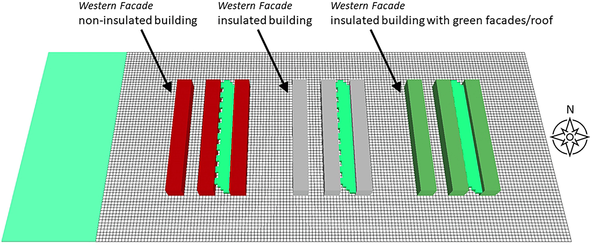
The artificial experiment domain is located at the latitude and longitude of Vienna on a 176 × 71 × 30 grid with a horizontal and vertical resolution of 2 m. To increase the model accuracy near the surface, the resolution of the lowest grid box is split into five sub cells. Nine buildings, clustered into three building blocks, form the core structure of the area (Fig. 1). Following the typical horizontal length scales suggested by Oke (2006), buildings are shaped 10 m high, 10 m wide, and 80 m long, forming 10 m wide street canyons with an aspect ratio of 1. Each building block consists of three buildings, shaping two street canyons with North-South orientation. In every block, one street is plain and one street is greened with trees (birches, betula pendula) in a dense alley style. The building block in the West is built of noninsulated construction material (“no-ins,” 2 cm plaster layer, 39 cm burned brick), the other two consist of moderately insulated walls (“ins,” 2 cm plaster layer, 12 cm insulation material, 18 cm concrete) with the block in the East covered with façade and roof greening without air gap and mixed substrate (“gf,” 30 cm greening, 10 cm sandy loam, 5 cm styrofoam). The leaf area index (LAI) of the greening is set to 1.0. A sensitivity experiment without substrate (Table 1), but same LAI is carried out as well. The soil material consists of dark concrete except for the Western area of the domain, where loamy soil with 25 cm grass is chosen.
| Experiment name | Domain setup | Wind speed and direction |
|---|---|---|
| Control | Control | 1 m/s, 180° (South) |
| E1 | 1 m/s, 90° (East) | |
| W1 | 1 m/s, 270° (West) | |
| N1 | 1 m/s, 0° (North) | |
| S1 rev | Reversed no-ins and gf | |
| E1 rev | Reversed no-ins and gf | 1 m/s, 90° (East) |
| W1 rev | Reversed no-ins and gf | 1 m/s, 270° (West) |
| N1 rev | Reversed no-ins and gf | 1 m/s, 0° (North) |
| No substrate | No substrate in façade/roof greening |
Note: Empty cells indicate that the configuration of the control experiment was not changed.
This idealized design of the experiment domain provides multiple evaluation opportunities to demonstrate pitfalls and potentials. Moreover, it enables the assessment of impacts of buildings and trees in street canyons on thermal comfort. The location and arrangement of building blocks provide an unshaded Western and Eastern wall of every material type outside and inside of a street canyon. For the evaluation in this study, only BST and AT in front of the façade of the outer Western wall are analyzed for different materials. The effect of trees on MRT and AT can be assessed as well through comparison of both street canyons of every block. The greened soil in the Western area forms an artificial rural area to partially simulate UHIE at different locations of the urban quarter. Evaluation of this area is not part of this study.
Sensitivity Experiments
To assess the impact of a set of influencing factors on AT, MRT, and BST in the model, a control experiment setup is defined and sensitivity experiments with altered conditions are conducted. The present study focuses solely on microclimate simulations and their sensitivity toward parameters or model specifications, therefore no validation with field data is conducted (Oke 2006).
The control experiment is setup as a hot summer day with clear sky (no clouds), air temperature boundary conditions of min. 20°C at 05:00 and max. 30°C at 16:00, and relative humidity of max. 75% (05:00) and min. 45% (16:00) with linear interpolation in between. Wind velocity is set to 1 m/s from the South to create similar conditions for all three tested construction materials. ACRT is activated and IVS resolution for height and azimuthal segment angles is set to medium (15°) for all experiments.
While the importance of air temperature values as input parameters for the microclimate simulation results is well known, influence of wind direction, transporting boundary conditions of various meteorological parameters into the model area, is often underestimated, and thus analyzed in this study through sensitivity experiments. Its influence on the results is quantified through experiments with altered wind directions for every cardinal direction. Additionally, an experiment with reversed locations of buildings of noninsulated material and green façade/roof is simulated for each wind direction to compare the strength of the impact of wind flow and construction material. To analyze the influence of façade greening type on BST, a sensitivity experiment is set up where façade and roof greening are applied without substrate while the control setup includes a substrate layer.
An overview of the control and sensitivity setups is provided in Table 1. All simulations are calculated starting on July 1, at 05:00 a.m. and are calculated for three consecutive days. For the verification of the experiments, only the third day and night are evaluated. The first day and night are considered as spin-up time of the model and the second day and night are considered as control time to detect any unrealistic parameter changes that indicate configuration errors.
Results
The design of the experiment domain together with conducted sensitivity experiments of this study reveal a number of pitfalls during different steps of the simulation process, for example, model and domain setup, choice of boundary conditions, and interpretation of results. Comparison of output parameters within the control setup and selected sensitivity experiments prove the importance and significance of proper model configuration and evaluation of simulation outputs. Analyzed cases demonstrate the necessity of critical reflection of ambivalent results and review of valid applicable conditions. The findings of this study investigate three impact areas of pitfalls in the conduction of microclimate simulations:
1.
impact of wind direction on AT;
2.
impact of time of day on MRT evaluation;
3.
relevance of selection of evaluation parameter.
To highlight relevant aspects from different angles, the selected areas are evaluated, and described in qualitative and quantitative terms in more detail.
Impact of Wind Direction on AT
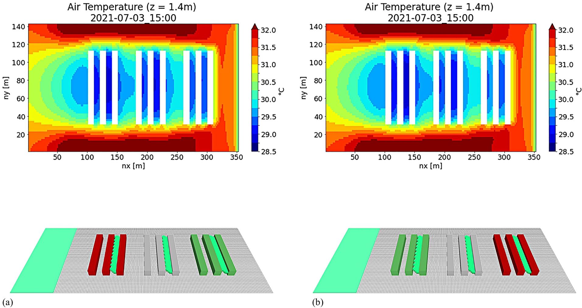
Wind direction of the boundary conditions in the model setup has a strong influence on the AT field of the microclimate simulation. While the control experiment shows expected results of lowest air temperatures in street canyons of the green façades/roof building block, the attribution of this result to construction material or greening measure is only valid because of the configured Southern wind direction. Its importance for the material impact assessment can be seen under different wind conditions. In the case of Eastern wind direction and similar wind speed (1 m/s), street canyons in the Eastern building block (green façades/roof) show higher air temperatures than in the middle and Western building block. A sensitivity experiment with exchanged construction materials, that is, noninsulated buildings in the East and green façades/roof of insulated buildings in the West, leads to similar results [Figs. 2(a and b)]. If only this last configuration is calculated, the wrong conclusion that noninsulated buildings generally lead to lower AT in the afternoon than the building configuration with green façades/roof might be drawn. It can be concluded that the impact of wind direction superimposes influence of construction material on AT. This fact is especially important when working in (full-) forcing mode based on a historical observation dataset. Only looking for a hot summer day in the available meteorological dataset without paying attention to wind direction might lead to misinterpretation of results of the microclimate simulation.
It must be stated that sensitivity of the local microclimate to wind direction is a real phenomenon and not a shortcoming of microclimate simulation models in general. Irradiance has a high spatial and temporal variation in microclimate analysis of urban spaces, influencing local generation of hot spots. As visible in Fig. 2, wind dynamics move air over hot and cool surfaces, accumulate air in blocked areas, ventilate street canyons, and thus impact local microclimate in models and reality. These results show that microclimate models with a computational fluid dynamics (CFD) wind model such as ENVI-Met can simulate highly local effects and prove their potential capability to model small-scale wind-induced meteorological phenomenon. Nevertheless, as it is not recommended to use wind velocities larger than 5 m/s in ENVI-Met, urban planning projects with special concerns for high wind speeds such as skyscrapers, terraces, railway stations, and so forth require specific CFD models (e.g., OpenFOAM) able to cope with requested extreme conditions.
Impact of Time of Day on MRT Evaluation
Evaluation of MRT (and thermal comfort indices) requires users of microclimate simulations to know exactly which parameter to evaluate at what times of the day. Results of this study show that evaluation of MRT during the night should not be used to argue for or against trees as NBSs.
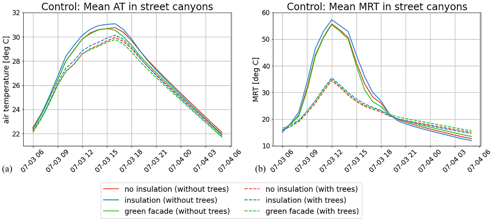
During the day, MRT is impacted by shortwave and longwave radiation and is one of the main drivers of thermal comfort indices. Effects of shade through buildings and trees can lead to differences of up to 35°C in MRT for single grid cells [Fig. 3(a)] and up to 20°C for spatially averaged mean MRT values [Fig. 4(b)]. As this parameter is spatially and temporally heterogeneous, statistical evaluation measures must be selected carefully. In this study, the impact of a dense alley of trees on MRT is also visible in spatially averaged mean values. The potential of trees as greening measure to enhance thermal comfort in urban environments for pedestrians and residents is evident. Comparison with the effect of trees on AT [Fig. 4(a)] shows the importance of evaluating MRT (or thermal comfort indices) in thermal comfort analyses.
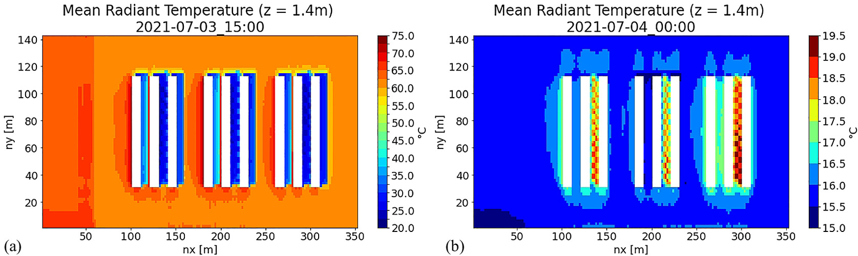
During the night, street canyons with trees lead to higher values of MRT than without trees, making trees look like umbrella heaters in 2D plots at night [Fig. 3(b)]. After sunset, MRT is solely based on longwave radiation and thus on all radiation emitting objects visible from the grid cell. Vegetation also emits longwave radiation and in the case of trees, they even block the sky view from lower grid cells, leading to higher MRT values below and nearby trees (and consequently higher values of UTCI and other thermal comfort indices). It must be mentioned that the differences in scale are low (up to 4°C), leading to a rather homogeneous field of MRT during the night. Even if it seems like trees have a negative influence on thermal comfort during hot summer nights when looking at MRT, the opposite is true. Continuous shading of pavement below trees and their evaporation capacities lead to lower air temperatures, enhanced thermal comfort, and even to a reduction of UHIE [Fig. 4(a)]. Impacts of trees on ventilation are not evaluated in this study.
In addition to the impact of trees on MRT, the influence of construction material on this parameter might also be of concern in simulation analyses. Emittance of longwave radiation at night is not always directly visible at all cardinal directions of a building in spatial analysis of MRT. In the case of higher surface temperatures of sun exposed Western oriented walls, it is [Fig. 3(b)]. Especially noninsulated buildings slowly emit the stored heat due to their high heat storage capacity. In the case of insulated buildings, surface temperature quickly falls below air temperature after sunset, leading to lower values of emitted longwave radiation. The reason is an insulation layer behind the 2 cm thin plaster compared with brick of noninsulated buildings. The plaster layer heats up strongly and quickly as soon as it is exposed to direct solar radiation and cools down at a similar pace after sunset or if the wall is shaded during the day. In the case of green façades, longwave radiation of vegetation leads to higher MRT values close to the building. In the street canyon of the insulated buildings, MRT values are even lower than in the open field. Causes are altered sky view factors close to buildings and can be explained based on a simplified approach of MRT calculation.
Illustrative Example of Simplified MRT Calculation
Within this idealized setting, absence of vegetation and spatially constant ground and building surface temperature of a given wall at a given point in time during the night (facilitation through absence of shortwave radiation) is assumed. In this case, three values of radiation (Qbuild, Qground, Qsky) and view factors for upper and lower hemisphere form the calculation of MRT. Through this simplification, individual contributions of every sphere facet to MRT does not need to be calculated. It is sufficient to use a view factor approach for upper and lower hemisphere and weight each hemisphere by 50%. With this method starting at a given location and looking at the upper hemisphere, the parameter “view factor upward building” and “view factor upward sky” specify the percentage of building and sky that are visible. The normed view factors consider the total weights of the given radiation values from the respective source (ground, building, sky) and hemisphere.
In Table 2, the calculated MRT in front of a Western oriented wall of an insulated building in three heights is compared with a value in the open area for a representative point in time on a cloud-free summer night. As the view sphere of the open area only varies marginally with height, the weighting values of ground and sky are kept constant at 0.5. In addition to absolute values of radiative fluxes (constant at all heights), view factors play an important role at varying heights close to buildings. Considering only the upper hemisphere, the higher a given grid cell is located in front of the wall, the larger the visible sphere of the sky and the smaller the visible sphere of the building. However, considering only the lower hemisphere, the higher the considered grid cell is located in front of the wall, the smaller the visible sphere of the ground and the larger the visible sphere of the building. As the longwave radiation from the ground is highest, followed by radiation from building and lastly from the sky, both points of view, upper and lower hemisphere, contribute to the decrease of MRT while increasing the height of the grid cell in front of the façade (in the case of the assumed radiation values). Thus, during a clear night, MRT close to an insulated building is always lower than in the open area, except for a layer directly above the ground.
| View factors | Open area | z = 0.2 m | z = 1.4 m | z = 7.0 m |
|---|---|---|---|---|
| Ground (view factor up) | 0 | 0 | 0 | 0 |
| Building (view factor up) | 0 | 0.35 | 0.3 | 0.25 |
| Sky (view factor up) | 1 | 0.65 | 0.7 | 0.75 |
| Sum (view factor up)a | 1 | 1 | 1 | 1 |
| Ground (view factor down) | 1 | 1 | 0.75 | 0.65 |
| Building (view factor down) | 0 | 0 | 0.25 | 0.35 |
| Sky (view factor down) | 0 | 0 | 0 | 0 |
| Sum (view factor down)b | 1 | 1 | 1 | 1 |
| Ground (normed view factor up) | 0 | 0 | 0 | 0 |
| Building (normed view factor up) | 0 | 0.175 | 0.15 | 0.125 |
| Sky (normed view factor up) | 0.5 | 0.325 | 0.35 | 0.375 |
| Ground (normed view factor down) | 0.5 | 0.5 | 0.375 | 0.325 |
| Building (normed view factor down) | 0 | 0 | 0.125 | 0.175 |
| Sky (normed view factor down) | 0 | 0 | 0 | 0 |
| Sum (normed view factor)c | 1 | 1 | 1 | 1 |
| Received LW radiation [W/m2]d | 400 | 403.5 | 398 | 395.5 |
| MRT [°C]e | 24.4 | 25.0 | 24.0 | 23.6 |
Note: Left column refers to open area (height not relevant), three right columns refer to given height levels next to a building.
a
Total view factor from the upper hemisphere (sum of ground, building and sky).
b
Total view factor from the lower hemisphere (sum of ground, building and sky).
c
Total normed view factor (sum of all normed view factors from ground, building and sky, upper and lower hemisphere).
d
Received longwave radiation at the specified cell of the domain.
e
Mean radiant temperature at the specified cell of the domain.
Potentials of MRT Evaluation in Microclimate Simulations
The detailed description of pitfalls in the evaluation of MRT results already provides core thoughts of potential applications. Microclimate simulations can simulate the effects of urban planning projects on outdoor thermal comfort (represented by MRT) and thus potential occupation zones, recreational areas, and unbearable spots of increased heat stress during summer days. The simple experiment domain in this study suggests higher comfort in narrow streets (N-S orientation) than broader avenues because of the shading function of buildings [Fig. 3(a)]. Based on MRT evaluation of initial architectural and spatial planning concepts, NBS and modifications of planned urban geometries can be applied to enhance the livability.
Moreover, the impact of a set of measures can be tested and compared with others. Retrofitting of recently constructed urban areas to provide additional shaded areas, green façades, trees, permeable pavements, or other cooling strategies can lead to enormous costs. Microclimate simulations can already be included in the planning phase to include proper cooling or greening measures for the given project and evaluate their contributions to improvements of MRT hotspots during the day.
Relevance of Selection of Evaluation Parameter
The selection of the right evaluation parameter to provide meaningful answers to proposed research questions is crucial. Proper choice of evaluation parameters of microclimate simulation results can support urban planners and real estate developers in the selection of most effective and efficient measures in terms of quality of stay, heat exposure, energy use, or reduced costs for future residents and communities. As an example, the effects of construction material and façade greening on AT and BST are provided. The main impacts of the analyzed construction materials and related climate adaption measures (e.g., green façades) are not direct reductions of AT in the surroundings. Yet, analysis of BST shows significant differences and can serve as relevant input for building energy models and demand for heating/cooling during different times of the year.
Impact of Construction Material on AT
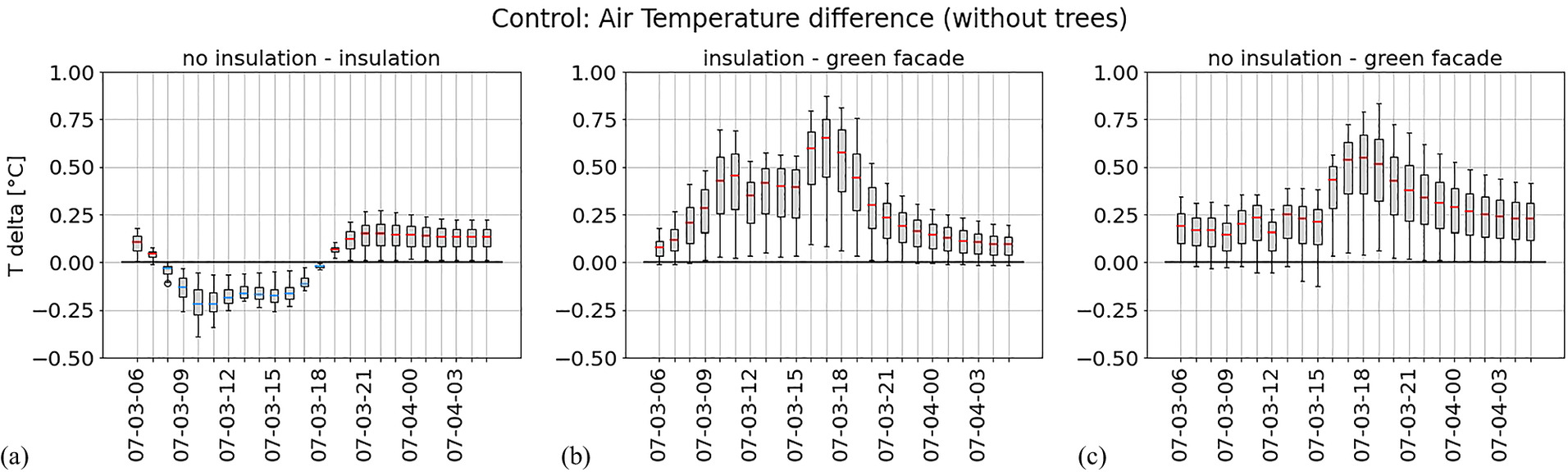
AT in street canyons without trees during the day is highest for insulated buildings with a median difference of approximately 0.13°C compared with the noninsulated buildings and around 0.5°C compared with the green façades. Maximum differences in this case reach 0.85°C. During the night, noninsulated buildings lead to highest AT with up to 0.2°C higher than in street canyons of insulated buildings and 0.25°C higher as with insulated buildings with green façades. For this impact evaluation of construction material on AT in the entire street canyon, mean hourly values of all grid points of a street (with and without trees separately) at a height of 1.4 m are calculated and depicted in Fig. 4(a). A more detailed analysis can be found in the comparison of temperature differences between individual construction materials through a basic statistical analysis via box plots for every hour of the day in Fig. 5 (in a street canyon without trees). For the comparisons, all grid points of the respective street canyons at the given height are considered. As it can be seen in this example, the choice of construction material and façade greening has an influence on AT, but differences are rather small and do not allow to assess the potential advantages or disadvantages of each material to their full extent.
Impact of Construction Material on BST
Evaluation of BST for a Western oriented façade (outer wall of a building block, 1.4 m height) at the given wall elements (Fig. 1) shows more significant differences (Fig. 6) than prior analyzed impact on AT. As the temperature impact from boundary conditions in the Southern part of the streets should be minimized, single wall elements in the Northern part of the street canyon were chosen instead of average values. The insulated building reaches highest BST with a peak of 56°C at 17:00. The surface temperature curve of the noninsulated building, in comparison with the insulated one, shows the inert system of its material. It does not heat up as strongly during the day but stores heat longer after sunset. Distances between building blocks are large enough that duration to sun exposure is nearly similar and earlier shading of the insulated building does not play a role.
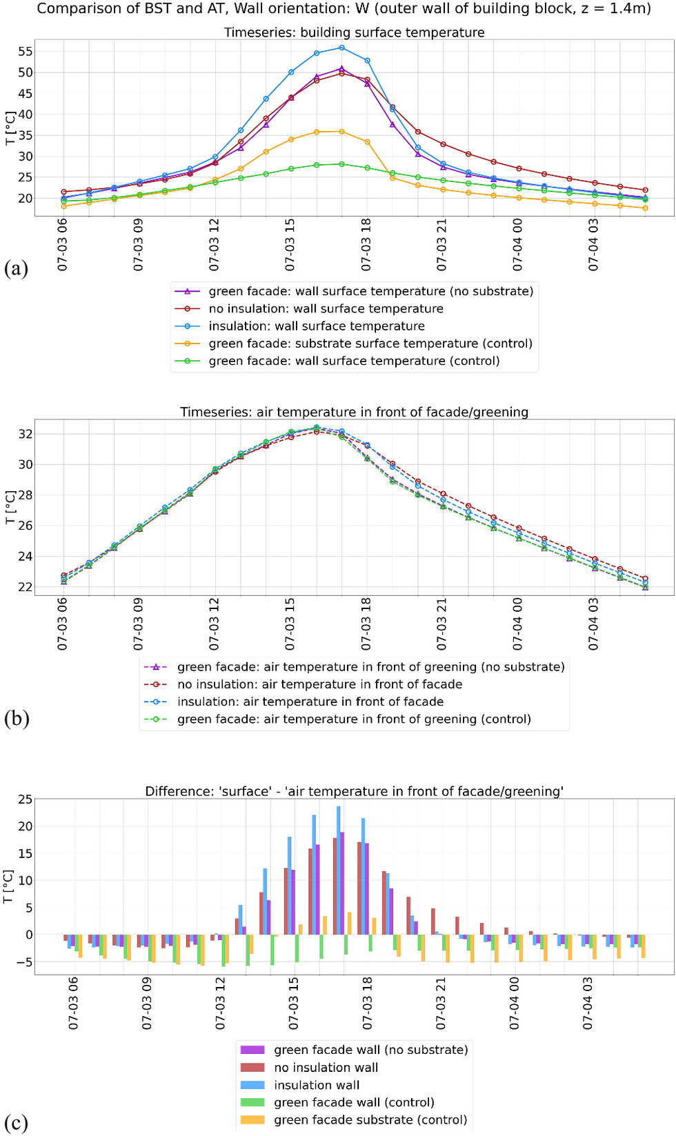
In the evaluated case of a Western oriented wall outside a street canyon, BST of the noninsulated building remains higher than AT until 02:00 a.m. In contrast, for a façade of a greened wall with substrate (as in the control run), BST stays below AT at all times of the day (this is true for all cardinal directions and street canyons with and without trees). This aspect can be attributed to the shading function of the leaves (LAI of 1.0), but mainly to the substrate layer acting as kind of additional insulation. Looking only at the temperature of the outermost surfaces during the night, the substrate shows the strongest cooling effect and highest negative difference to AT of approximately 5°C. A green façade without substrate layer still benefits from the shading function of the leaves. Its BST also stays below the bare insulated wall by approximately 5°C during daytime (comparable to a noninsulated wall). During the night, it cools down to comparable values of the insulated building. Higher values of LAI promise even stronger effects (lower BST). Both façade greenings (with and without substrate) therefore combine advantages of insulated and noninsulated buildings in terms of BST, with stronger cooling effects of the version with a substrate layer.
Discussion
Results of conducted control and sensitivity experiments provide insights to the intricacy of the interpretation of microclimate simulations. Investigated performance indicators AT, MRT, and BST can show similar characteristics for tested conditions, but also contradictory results. In both cases, magnitude, and spatial and temporal effects can differ strongly.
Example 1. During the night, MRT is higher in street canyons with trees than without trees (due to less sources of longwave radiation in the latter), while the opposite is true for AT because of tree-shaded surfaces during the day.
Example 2. Façade greening not only leads to minor reduction of AT during the day in a street canyon, but to significantly lower BST because of its shading function for the building envelope.
Example 3. While noninsulated buildings lead to lower BST and AT in a street canyon during the day compared with an insulated building, the opposite is true during the night due to the insulation behind the rapidly cooling outer plaster layer.
These three examples from the experiment results prove the need to evaluate and compare multiple indicators on a spatial and temporal scale to get a complete picture of the microclimate.
Results from this study further demonstrate the impact of poorly adjusted meteorological boundary conditions and domain setup, such as wrong conclusions and adverse decisions for the local microclimate. Thus, deliberately chosen boundary parameters as wind direction or air temperature, together with correct evaluation processes, are critical success factors for decisions by authorities and the urban planning community. Present findings shall support urban planners and other users of microclimate simulations in the proper application by simultaneously demonstrating cautionary examples of their misuse. It urges users to clearly specify posed research question, application, and use case to be elaborated on and simultaneously be aware of additionally (unintentionally) affected parameters. As an example, the effects of lighter surface colors to reduce UHIE are pointed out. In the scientific literature, usage of high-albedo surfaces in urban areas has been studied intensively and the results need to be interpreted with care. While the impact on AT and BST can be beneficial for the cooling demands in summer, it might have negative consequences for MRT and thermal comfort (Lopez-Cabeza et al. 2022). Increased reflected solar radiation from walls and ground surfaces can adversely affect thermal comfort (Erell et al. 2014), but also be evaluated positively (Santamouris et al. 2012). Especially in complex settings, contradictory results can be found in the literature due to differing prerequisites, spatial and geographical context, evaluation metrics, experimental setups, or research foci, and exact comparisons are difficult to achieve.
The results of this exemplary study coincide with other research for the most part. Huttner (2012) examined the influence of BST on AT with a difference of up to 2°C in BST (assumed maximum mean value in 1.8 m height) leading to a difference of 0.3°C in AT (assumed maximum mean value of the entire street canyon). In the present study, the mean difference between 12:00 and 17:00 of BST of one wall element of the Western and Eastern wall of the street canyon without trees in the insulated and noninsulated building block is calculated and compared with the mean difference of AT. Differences in BST of 3.3°C for the Western and 1.3°C for the Eastern wall correspond to changes in AT of 0.2°C. Even if only single points are examined to evaluate BST in the present work, the comparison of results leads to reasonable comparable values.
The same is true for the impact of a green façade. Its function as nature-based solution to reduce UHIE has been addressed in multiple studies. The impact on air temperature in a street canyon has been quantified by a maximum temperature difference of 0.5°C (Blocken et al. 2016), 1.3°C (Wong et al. 2010) and 0.85°C in the present study. The impact of green façades on MRT in front of the façade has been analyzed by Jänicke et al. (2015) with a reduction of 2.13 ± 1.81°C. Compared with the mean difference values of 3°C during the day in this study, the values seem reasonable, even if a reduction of 3°C in MRT only marginally contributes to an enhancement of thermal comfort. The potentially largest impact of green façades can be found in the reduction of BST. A difference of up to 6.1°C (without substrate on a Western oriented wall) is consistent with 5°C–7°C (Blanco et al. 2018) and 5.5°C–6.3°C (Safikhani et al. 2014). Higher values have been found by Hoelscher et al. (2016) with 10.5°C–15.5°C. Different values of LAI for the green façade may be a reason. Through the application of a substrate layer, a reduction of up to 27.5°C could be simulated in this study. The wide spread of results shows the relevance and impact of façade greening type on BST, while the impact on AT did not prove any significant dependence (Hoelscher et al. 2016). Roof greening as an additional feature has been applied together with façade greening in this study but has not been evaluated exclusively.
In addition to the importance of statistical evaluation of the output of the simulation, the influence of meteorological boundary conditions for the simulation input needs special consideration. Prior knowledge about the prevalent wind direction for the requested case study should be gained. As shown in the sensitivity experiments with modified wind directions, a change in this parameter might lead to an entirely different picture of the analysis. To cope with this pitfall, analysis of main wind direction and speed during hot summer days can provide insights of suitable initial and boundary conditions for the simulation. Meteorological input data are often retrieved from representative climatological data of a weather station in the vicinity. Even if WMO standards apply for the station, local and temporal wind effects still exist in the analyzed domain. Loibl et al. (2021) provide an example of changed prevalent wind direction in case the maximum temperature rises above 30°C. While the main wind direction in Vienna between 1989 and 2018 is West to North-West, the prevalent wind direction for heat days is South-East. Consideration of this aspect potentially improves the quality of results in that area. Moreover, a relaxation zone large enough to reduce boundary effects for the inner area of interest needs to be applied. For stability reasons of the model, it can also be even more practicable to set wind constant at a given velocity and direction. The chosen direction in this case should represent the main direction for the requested type of day to analyze (e.g., hot summer day). Alternatively, additional simulations with altered wind directions can support the evaluation of the urban planning project.
The above-mentioned comparisons of the results of different studies give an idea of the multitude of possibilities to conduct and evaluate microclimate simulations. To summarize results and facilitate interpretation and comparison, averaged results are often communicated in studies. However, simple spatial and temporal averaging involves the risk to neglect important results and lose meaningful outcome of a study or project, for example, spatially heterogeneous field of MRT at 15:00. Especially in urban planning where local characteristics play an important role, it is recommended to at least expand the evaluation metrics to basic statistical values (mean, median, maximum, minimum), even if this increases complexity of the situation, to sum up and provide comprehensible results. It is also good practice to explain the spatial and temporal frame of calculation of the given measure.
The complexity, application, and interaction from multiple disciplines (urban planning, meteorology, physics, statistics) complicate the accurate conduction and interpretation of microclimate simulations on different levels. Expertise from different fields needs to be gained to holistically approach the improvement of the local microclimate. Remarks and explanations raised in this study do not aim to hamper the application of microclimate models but encourage users of the urban planning community to be attentive and critical in the model setup and interpretation of their results.
Conclusion
The exemplary case study of a microclimate simulation on a hot summer day with ENVI-Met provides a selection of pitfalls and potentials of microclimate simulations with focus on the performance indicators AT, MRT, and BST. Conducted control and sensitivity experiments prove the need to avoid outlined pitfalls, including
1.
underestimation of the impact of boundary conditions of wind direction in the experiment setup, which affect AT in the domain and might superimpose other impact factors (e.g., construction material, greening measures), thus leading to misinterpretation of results
2.
interpretation of MRT as the driver of thermal comfort at different times of the day, including misleading results during nighttime
3.
choice of the wrong evaluation parameter to make statements about the impact of given climate change adaption/mitigation measures (e.g., impact of construction material on BST and AT)
Objectives and questions to be answered by a microclimate simulation need to be clearly specified to set up a proper experiment design, boundary conditions, and select appropriate evaluation indicators. Based on this information, statistical evaluation metrics can be chosen and calculated. Single points in space and time as well as mean, median, minimum, maximum values and others can serve as valid indices. Improper application of microclimate models and use of inappropriate evaluation parameters can lead to ambiguous results, wrong interpretations, incorrect assessment of local microclimate, and ultimately promote urban planning projects more harmful to the climate instead of climate-friendly concepts.
A remaining open research area not tackled in this study is the length of the simulation period. Simulations in this research have been conducted for three consecutive hot summer days. Longer periods would be of interest to assess effects of NBS and other cooling measures during a heat wave period on various performance indicators. Furthermore, missing irrigation measures, open or closed windows, anthropological heating through air conditioning, and other adaption measures influencing microclimate in urban street canyons have not been considered in this study and should be implemented accordingly in the future. Additional future research potential includes the influence of the size of a buffer zone and obstacles at the domain border on the results of the simulation, which might reveal not yet tackled pitfalls.
Following the recommendations in this paper, microclimate simulations can support the urban planning community from the start of the planning process to the final implementation with quantified information about wind dynamics in complex environments, thermal comfort in outdoor areas, impacts of climate adaption and mitigation measures, effects of construction material, optimized street geometry, urban morphology, design of urban quarters, and so forth. The tools for the assessment of microclimatic impact of urban planning projects need to be used with precision and knowledge about model setup, boundary conditions, and evaluation of the required performance indicators. As urban planning projects always have financial limitations, concise impact assessments of potential climate adaption and mitigation measures are required to support decision makers on the way to improved microclimate in cities worldwide.
Data Availability Statement
Some or all data, models, or code that support the findings of this study are available from the corresponding author upon reasonable request.
Acknowledgments
This work was supported by the research project GreenDeal4Real, funded by the Austrian Research Promotion Agency (FFG), the promotional bank of the Austrian federal government (AWS), and the Austrian Society for Environment and Technology (OEGUT) on behalf of the Federal Ministry for Climate Action, Environment, Energy, Mobility, Innovation, and Technology (BMK) in the research and technology program “City of the Future” (ger. “Stadt der Zukunft”) [Grant No. 879456].
Author contributions: Martin Schneider: Conceptualization, Methodology, Formal analysis, Investigation, Writing – Original Draft, Visualization; Tanja Tötzer: Conceptualization, Writing – Review and Editing, Supervision, Project administration, Funding acquisition; Marianne Bügelmayer-Blaschek: Writing – Review and Editing; Romana Stollnberger: Writing – Review and Editing, Project administration, Funding acquisition.
References
Abdollahzadeh, N., and N. Biloria. 2021. “Outdoor thermal comfort: Analyzing the impact of urban configurations on the thermal performance of street canyons in the humid subtropical climate of Sydney.” Front. Archit. Res. 10 (2): 394–409. https://doi.org/10.1016/j.foar.2020.11.006.
Albdour, M. S., and B. Baranyai. 2019. “An overview of microclimate tools for predicting the thermal comfort, meteorological parameters and design strategies in outdoor spaces.” Pollack Periodica 14 (2): 109–118. https://doi.org/10.1556/606.2019.14.2.10.
Ali-Toudert, F. 2005. “Dependence of outdoor thermal comfort on street design in hot and dry climate.” Ph.D. thesis, Faculty of Environment and Natural Resources, Univ. Freiburg.
Ali-Toudert, F., and H. Mayer. 2006. “Numerical study on the effects of aspect ratio and orientation of an urban street canyon on outdoor thermal comfort in hot and dry climate.” Build. Environ. 41 (2): 94–108. https://doi.org/10.1016/j.buildenv.2005.01.013.
Ambrosini, D., G. Galli, B. Mancini, I. Nardi, and S. Sfarra. 2014. “Evaluating mitigation effects of urban heat islands in a historical small center with the ENVI-met® climate model.” Sustainability 6 (10): 7013–7029. https://doi.org/10.3390/su6107013.
Arkon, C. A., and Ü. Özkol. 2014. “Effect of urban geometry on pedestrian-level wind velocity.” Archit. Sci. Rev. 57 (1): 4–19. https://doi.org/10.1080/00038628.2013.835709.
Arnfield, A. J. 1990. “Street design and urban canyon solar access.” Energy Build. 14 (2): 117–131. https://doi.org/10.1016/0378-7788(90)90031-D.
ASHRAE (The American Society of Heating, Refrigerating and Air-Conditioning Engineers). 2001. ASHRAE handbook: Fundamentals. Atlanta, GA: ASHRAE.
Bay, J. 2006. Tropical sustainable architecture: Social and environmental dimensions. Burlington, NJ: Elsevier.
Blanco, I., E. Schettini, G. S. Mugnozza, and G. Vox. 2018. “Thermal behaviour of green façades in summer.” J. Agric. Eng. 49 (3): 183–190. https://doi.org/10.4081/jae.2018.835.
Blocken, B., and J. Carmeliet. 2004. “Pedestrian wind environment around buildings: Literature review and practical examples.” J. Therm. Envelope Build. Sci. 28 (2): 107–159. Retrieved on May 19, 2022. https://doi.org/10.1177/1097196304044396.
Blocken, B., J. Hensen, H. Timmermans, T. van Hoof, and C. Gromke. 2016. “Adapting buildings and cities to heat waves: are green solutions the best?” Accessed May 5, 2022. https://www.linkedin.com/pulse/adapting-buildings-cities-heat-waves-green-solutions-best-blocken.
Bröde, P., D. Fiala, K. Błażejczyk, I. Holmér, G. Jendritzky, B. Kampmann, B. Tinz, and G. Havenith. 2012. “Deriving the operational procedure for the universal thermal climate index (UTCI).” Int. J. Biometeorol. 56 (3): 481–494. https://doi.org/10.1007/s00484-011-0454-1.
Bruse, M. 1999. “Die Auswirkungen kleinskaliger Umweltgestaltung auf das Mikroklima – Entwicklung des prognostischen numerischen Modells zur Simulation der Wind-, Temperatur- und Feuchteverteilung in städtischen Strukturen.” Ph.D. thesis, Faculty of Geosciences, Ruhr-Univ. Bochum.
Chudnovsky, A., E. Ben-Dor, and H. Saaroni. 2004. “Diurnal thermal behavior of selected urban objects using remote sensing measurements.” Energy Build. 36 (11): 1063–1074. https://doi.org/10.1016/j.enbuild.2004.01.052.
Dissegna, M. A., T. Yin, H. Wu, N. Lauret, S. Wei, J.-P. Gastellu-Etchegorry, and A. Grêt-Regamey. 2021. “Modeling mean radiant temperature distribution in urban landscapes using DART.” Remote Sens. 13 (8): 1443. https://doi.org/10.3390/rs13081443.
ENVI-Met. 2022. “Envi-met model architecture.” Accessed May 3, 2022. https://envi-met.info/doku.php?id=intro:modelconcept.
Erell, E., D. Pearlmutter, D. Boneh, and P. B. Kutiel. 2014. “Effect of high-albedo materials on pedestrian heat stress in urban street canyons.” Urban Clim. 10: 367–386. https://doi.org/10.1016/j.uclim.2013.10.005.
Good, E. J., D. J. Ghent, C. E. Bulgin, and J. J. Remedios. 2017. “A spatiotemporal analysis of the relationship between near-surface air temperature and satellite land surface temperatures using 17 years of data from the ATSR series.” J. Geophys. Res.: Atmos. 122 (17): 9185–9210. https://doi.org/10.1002/2017JD026880.
Görgen, F., and M. Rossi-Schwarzenbeck. 2021. “Evaporative cooling strategies in urban areas: The potential of vertical greening systems to reduce nocturnal heat stress.” J. Phys. Conf. Ser. 2042 (1): 012056. https://doi.org/10.1088/1742-6596/2042/1/012056.
Gu, K., Y. Fang, Z. Qian, Z. Sun, and A. Wang. 2020. “Spatial planning for urban ventilation corridors by urban climatology.” Ecosyst. Health Sustainability 6 (1): 1747946. https://doi.org/10.1080/20964129.2020.1747946.
Han, H., J. Lee, J. Kim, C. Jang, and H. Jeong. 2014. “Thermal comfort control based on a simplified predicted mean vote index.” Energy Procedia 61: 970–974. https://doi.org/10.1016/j.egypro.2014.11.1006.
Hoelscher, M.-T., T. Nehls, B. Jänicke, and G. Wessolek. 2016. “Quantifying cooling effects of facade greening: Shading, transpiration and insulation.” Energy Build. 114: 283–290. https://doi.org/10.1016/j.enbuild.2015.06.047.
Höppe, P. 1999. “The physiological equivalent temperature – a universal index for the biometeorological assessment of the thermal environment.” Int. J. Biometeorol. 43 (2): 71–75. https://doi.org/10.1007/s004840050118.
Huttner, S. 2012. “Further development and application of the 3D microclimate simulation ENVI-met.” Ph.D. thesis, Faculty of Chemistry, Pharmaceutical Sciences, Geography and Geosciences, Johannes Gutenberg-Univ.
Jänicke, B., F. Meier, M.-T. Hoelscher, and D. Scherer. 2015. “Evaluating the effects of façade greening on human bioclimate in a complex urban environment.” Adv. Meteorol. 2015: 1–15. https://doi.org/10.1155/2015/747259.
Kehrer, M., and T. Schmidt. 2008. “Radiation effects on exterior surfaces.” In Proc., 8th Nordic Symp. Building Physics. Nordic Countries, edited by C. Rode. Copenhagen, Denmark: Danish Society of Engineers.
Kwon, Y. J., and D. K. Lee. 2019. “Thermal comfort and longwave radiation over time in urban residential complexes.” Sustainability 11 (8): 2251. https://doi.org/10.3390/su11082251.
Lee, H., S. Jo, and S. Park. 2022. “A simple technique for the traditional method to estimate mean radiant temperature.” Int. J. Biometeorol. 66 (3): 521–533. https://doi.org/10.1007/s00484-021-02213-x.
Loibl, W., M. Vuckovic, G. Etminan, M. Ratheiser, S. Tschannett, and D. Österreicher. 2021. “Effects of densification on urban microclimate—a case study for the city of Vienna.” Atmosphere 12 (4): 511. https://doi.org/10.3390/atmos12040511.
Lopez-Cabeza, V. P., S. Alzate-Gaviria, E. Diz-Mellado, C. Rivera-Gomez, and C. Galan-Marin. 2022. “Albedo influence on the microclimate and thermal comfort of courtyards under Mediterranean hot summer climate conditions.” Sustainable Cities Soc. 81: 103872. https://doi.org/10.1016/j.scs.2022.103872.
Maggiotto, G., R. Buccolieri, M. A. Santo, L. S. Leo, and S. Di Sabatino. 2014. “Validation of temperature-perturbation and CFD-based modelling for the prediction of the thermal urban environment: The lecce (IT) case study.” Environ. Modell. Software 60: 69–83. https://doi.org/10.1016/j.envsoft.2014.06.001.
Mauree, D., S. Coccolo, A. Perera, V. Nik, J.-L. Scartezzini, and E. Naboni. 2018. “A new framework to evaluate urban design using urban microclimatic modeling in future climatic conditions.” Sustainability 10 (4): 1134. https://doi.org/10.3390/su10041134.
Mosteiro-Romero, M., D. Maiullari, M. Pijpers-van Esch, and A. Schlueter. 2020. “An integrated microclimate-energy demand simulation method for the assessment of urban districts.” Environ. Modell. Software 6. https://doi.org/10.3389/fbuil.2020.553946.
Naboni, E., M. Meloni, C. Makey, and J. Kaempf. 2019. “The simulation of mean radiant temperature in outdoor conditions: A review of software tools capabilities.” In Proc., 16th Building Simulation Conf., edited by V. Corrado, E. Fabrizio, A. Gasparella, and F. Patuzzi. Shanghai, China: International Building Performance Simulation Association (IBPSA).
Nunez, M., and T. R. Oke. 1977. “The energy balance of an urban canyon.” J. Appl. Meteorol. 16 (1): 11–19. https://doi.org/10.1175/1520-0450(1977)016%3C0011:TEBOAU%3E2.0.CO;2.
Oke, T. R. 2006. “Towards better scientific communication in urban climate.” Theor. Appl. Climatol. 84 (1–3): 179–190. https://doi.org/10.1007/s00704-005-0153-0.
Ouyang, W., T. Sinsel, H. Simon, T. E. Morakinyo, H. Liu, and E. Ng. 2022. “Evaluating the thermal-radiative performance of ENVI-met model for green infrastructure typologies: Experience from a subtropical climate.” Build. Environ. 207: 108427. https://doi.org/10.1016/j.buildenv.2021.108427.
Pacifici, M. 2019. “Urban morphology and climate: Field assessment and numerical modeling of interactions.” Ph.D. thesis, Dept. of Civil Engineering Construction, Univ. de Sao Paulo.
Prakash, A. 2000. “Thermal remote sensing: Concepts, issues and applications.” In Vol. 33(B1) of Proc., Int. Archives of Photogrammetry and Remote Sensing Amsterdam, The Netherlands: The International Society for Photogrammetry and Remote Sensing (ISPRS).
Qiao, Z., G. Tian, and L. Xiao. 2013. “Diurnal and seasonal impacts of urbanization on the urban thermal environment: A case study of Beijing using MODIS data.” ISPRS J. Photogramm. Remote Sens. 85: 93–101. https://doi.org/10.1016/j.isprsjprs.2013.08.010.
Safikhani, T., A. M. Abdullah, D. R. Ossen, and M. Baharvand. 2014. “Thermal impacts of vertical greenery systems.” Environ. Clim. Technol. 14 (1): 5–11. https://doi.org/10.1515/rtuect-2014-0007.
Salata, F., I. Golasi, R. de Lieto Vollaro, and A. de Lieto Vollaro. 2016. “Urban microclimate and outdoor thermal comfort. a proper procedure to fit ENVI-met simulation outputs to experimental data.” Sustainable Cities Soc. 26: 318–343. https://doi.org/10.1016/j.scs.2016.07.005.
Salvati, A., and M. Kolokotroni. 2019. “Microclimate data for building energy modelling: Study on ENVI-met forcing data.” In Proc., 16th Building Simulation Conf. of IBPSA, edited by V. Corrado, E. Fabrizio, A. Gasparella, and F. Patuzzi. New York: Taylor & Francis.
Santamouris, M., N. Gaitani, A. Spanou, M. Saliari, K. Giannopoulou, K. Vasilakopoulou, and T. Kardomateas. 2012. “Using cool paving materials to improve microclimate of urban areas – design realization and results of the flisvos project.” Build. Environ. 53: 128–136. https://doi.org/10.1016/j.buildenv.2012.01.022.
Shahmohamadi, P., A. I. Che-Ani, K. N. A. Maulud, N. M. Tawil, and N. A. G. Abdullah. 2011. “The impact of anthropogenic heat on formation of urban heat island and energy consumption balance.” Urban Stud. Res. 2011: 1–9. https://doi.org/10.1155/2011/497524.
Sharifi, E., and S. Lehmann. 2014. “Comparative analysis of surface urban heat island effect in central Sydney.” J. Sustainable Dev. 7 (3). https://doi.org/10.5539/jsd.v7n3p23.
Simon, H., M. Bruse, and L. Kissel. 2017. “Evaluation of ENVI-met’s multiple-node model and estimation of indoor climate.” In Proc., 33rd Passive and Low Energy Architecture: Design to Thrive, edited by L. Brotas, S. Roaf, and F. Nicol. Edinburgh, Scotland: Network for Comfort and Energy Use in Buildings (NCEUB).
Simon, H., T. Sinsel, and M. Bruse. 2021. “Advances in simulating radiative transfer in complex environments.” Appl. Sci. 11 (12): 5449. https://doi.org/10.3390/app11125449.
Singh, N., S. Singh, and R. Mall. 2020. “Urban ecology and human health: Implications of urban heat island, air pollution and climate change nexus.” In Urban ecology, edited by P. Verma, P. Singh, R. Singh, and A. S. Raghubanshi. 317–334. Amsterdam, The Netherlands: Elsevier.
Sinsel, T., H. Simon, W. Ouyang, C. D. S. Gusson, P. Shinzato, and M. Bruse. 2022. “Implementation and evaluation of mean radiant temperature schemes in the microclimate model ENVI-met.” Urban Climate 45: 101279.
Terjung, W. H., and P. A. O’Rourke. 1980. “Simulating the causal elements of urban heat islands.” Boundary Layer Meteorol. 19 (1): 93–118. https://doi.org/10.1007/BF00120313.
Tsoka, S., A. Tsikaloudaki, and T. Theodosiou. 2018. “Analyzing the ENVI-met microclimate model’s performance and assessing cool materials and urban vegetation applications–a review.” Sustainable Cities Soc. 43: 55–76. https://doi.org/10.1016/j.scs.2018.08.009.
UCAR (University Corporation for Atmospheric Research). 2018. Conduction. Accessed March 24, 2022. https://scied.ucar.edu/learning-zone/earth-system/conduction.
United Nations, Department of Economic and Social Affairs, Population Division. 2019. World urbanization prospects 2018: Highlights. New York: United Nations Publications.
Vuckovic, M., W. Loibl, T. Tötzer, and R. Stollnberger. 2019. “Potential of urban densification to mitigate the effects of heat island in Vienna, Austria.” Environments 6 (7): 82. https://doi.org/10.3390/environments6070082.
Walikewitz, N., B. Jänicke, M. Langner, F. Meier, and W. Endlicher. 2015. “The difference between the mean radiant temperature and the air temperature within indoor environments: A case study during summer conditions.” Build. Environ. 84: 151–161. https://doi.org/10.1016/j.buildenv.2014.11.004.
Wong, N. H., A. Y. Kwang Tan, Y. Chen, K. Sekar, P. Y. Tan, D. Chan, K. Chiang, and N. C. Wong. 2010. “Thermal evaluation of vertical greenery systems for building walls.” Build. Environ. 45 (3): 663–672. https://doi.org/10.1016/j.buildenv.2009.08.005.
Yang, X., L. Zhao, M. Bruse, and Q. Meng. 2013. “Evaluation of a microclimate model for predicting the thermal behavior of different ground surfaces.” Build. Environ. 60: 93–104. https://doi.org/10.1016/j.buildenv.2012.11.008.
Zhang, J., Z. Li, Y. Wei, and D. Hu. 2022. “The impact of the building morphology on microclimate and thermal comfort-a case study in Beijing.” Build. Environ. 223: 109469. https://doi.org/10.1016/j.buildenv.2022.109469.
Information & Authors
Information
Published In

Journal of Urban Planning and Development
Volume 149 • Issue 4 • December 2023
Copyright
This work is made available under the terms of the Creative Commons Attribution 4.0 International license, https://creativecommons.org/licenses/by/4.0/.
History
Received: Jan 10, 2023
Accepted: Jul 10, 2023
Published online: Oct 6, 2023
Published in print: Dec 1, 2023
Discussion open until: Mar 6, 2024
ASCE Technical Topics:
- Air temperature
- Building design
- Case studies
- Computer programming
- Computer software
- Computing in civil engineering
- Design (by type)
- Engineering fundamentals
- Engineering mechanics
- Infrastructure
- Measurement (by type)
- Methodology (by type)
- Models (by type)
- Research methods (by type)
- Simulation models
- Temperature (by type)
- Temperature effects
- Temperature measurement
- Thermal properties
- Thermodynamics
- Urban and regional development
- Urban areas
Authors
Metrics & Citations
Metrics
Citations
Download citation
If you have the appropriate software installed, you can download article citation data to the citation manager of your choice. Simply select your manager software from the list below and click Download.