Watershed-Scale Strategies to Increase Resilience to Climate-Driven Changes to Surface Waters: North American Electric Power Sector Case Study
Publication: Journal of Water Resources Planning and Management
Volume 149, Issue 5
Abstract
This case study synthesizes strategies that electric power utilities can implement to reduce surface water risks to infrastructure, operations, and regulatory compliance as climate change impacts hydrologic regimes over the next century. The strategies range from the reach scale to watershed scale. A reach-scale example would be evaluating relocation alternatives for a transmission tower along an eroding streambank versus a streambank stabilization strategy. A watershed-scale strategy would involve the value engineering of stormwater management strategies that could be implemented across a catchment that is restorative of a more natural flow regime such as prolonged baseflows and reduced flooding and erosion. The cost-effective watershed-scale strategies highlighted herein include retrofits of existing detention ponds, beaver reintroductions (or discontinued extirpation), riparian reforestation, adding wood to headwater streams, and the removal of postsettlement alluvium from floodplains coinciding with restoration of floodplain wetlands. Many of these strategies are management approaches that could be implemented on utilities’ own property for relatively little cost while appealing to broader societal goals such as environmental restoration. Although costs will vary by setting and program goals, we hope that this article is a launching point for infrastructure managers to consider holistic, watershed-scale approaches to provide durable infrastructure resilience in the face of increased extreme events while contributing to long-term economic, social, and environmental sustainability.
Introduction
Changing climate conditions are expected to result in increased surface water temperatures (Milly et al. 2005), impaired aquatic habitats and water quality (Ficklin et al. 2013), flashier and more erosive stream flow regimes (Hidalgo et al. 2009; Taur et al. 2019), increased channel instability (Booth and Jackson 1997; Hawley and Bledsoe 2013; Chin et al. 2017), and increased frequency and severity of environmentally hazardous events like floods and droughts (Stocker 2014; Swain et al. 2018; EPRI 2020a). These changing surface water conditions can pose risks to aquatic ecosystems (Poff et al. 1997; Nelson and Palmer 2007; Hawley et al. 2016) and the infrastructure on which our societies depend (Hawley et al. 2020; EPRI 2020b). In one Northern Kentucky case study, for example, flooding and erosion damaged state highways at a rate of ~$10,000 per square kilometer of developed drainage area per year (Hawley et al. 2013). In another study, Parola et al. (1998) documented ~$158M in impacts to federally funded highways from the 1993 upper Mississippi River flood.
The electric power sector’s distribution infrastructure faces similar flooding and erosion risks to transportation infrastructure because of their similarly distributed nature. Electric power utilities also face notable risks to power generation facilities, operations, and regulatory compliance (EPRI 2020b, c). Stocker (2014) projects increased flood frequency and severity as the climate continues to change, which can increase the risk of inundation to power generation facilities, as well as reservoir overtopping and ash pond failures. A large majority of power generating facilities are vulnerable to increased droughts and reduced source water for hydroelectric generation and cooling at thermoelectric generation facilities (van Vliet et al. 2016). Less source water and higher water temperatures (Milly et al. 2005) could also lead to less efficient cooling and reduced thermoelectric capacity (van Vliet et al. 2012). Water quality risks could mean more stringent effluent requirements, such as temperature and dissolved oxygen levels, and adjustments to environmental flow targets (Poff et al. 2010). Increased stream instability due to a more erosive flow regime (Hawley and Bledsoe 2013; Vietz et al. 2014; Plumb et al. 2017) can result in damages to transmission and distribution networks and scour and sedimentation at power plant intakes (Webb et al. 2021). Changing surface water conditions also pose risks to supply chains at bridges, ports, and to river transport. More stressed aquatic resources could lead to more challenging regulatory compliance (EPRI 2020b) and increased public pressure for environmental stewardship by power utilities (EPRI 2020c). With changing surface water conditions posing such widespread threats to electric power utilities, it is important for utilities to expand their management tools and planning horizons to be able to tailor environmentally and socioeconomically sustainable strategies that maintain system resilience and reliability over the next century.
Adaptive Strategies for Individual Risks
Floods
Conventional approaches to mitigate the risks posed to electric power utilities from changing surface water conditions typically focus on individual risks (Table 1). Extreme flooding poses some of the most severe risks to electric power utilities (e.g., inundation to power generation facilities, reservoir overtopping, and ash pond failures), and this century is anticipated to experience increases in flood frequencies and magnitudes (Stocker 2014; Kundzewicz et al. 2018). Recent revisions to standard recurrence interval analyses already reflect such increases, with, for example, the 100-year, 24 h rainfall depth in Austin, Texas, increasing by 25% after incorporating rainfall records from Hurricane Harvey (Taur et al. 2019; Perica et al. 2018). Furthermore, when developing and evaluating mitigation strategies using standard design storms, such as the 100-year event, it is important to factor in the influence that shifting seasons, vegetation, and land use can have on flood stage (Stephens and Bledsoe 2020). For example, high antecedent soil moisture conditions, dense channel and floodplain vegetation, floodplain infilling by other property owners, and other factors can all contribute to flood inundation risks that are outside conventional regulatory floodplain boundaries. Modeling assumptions (e.g., stationarity versus nonstationarity, etc.) can also affect uncertainty and lead to wider zones of potential inundation. Probabilistically accounting for such uncertainty can help utilities plan for flood inundation levels and frequencies that are agreeable to stakeholders. When developing flood models for long-term planning, managers can make more informed decisions by using hydrologic models that are better equipped for future climate and emissions scenarios [e.g., Soil and Water Assessment Tool (SWAT), EPRI 2020a].
| Risks | Possible utility impacts | Adaptive strategies | Comprehensive strategy |
|---|---|---|---|
| Floods | Facility inundation | Probabilistic planning to better understand the risks of inundation to adapt emergency response plans to levels of risk that are acceptable to stakeholders | Invest in watershed controls to promote a more natural flow regime to… |
| Reservoir overtopping | Spillway improvements, adaptive management of reservoir levels, etc. | …reduce flood magnitudes, prolong baseflows, improve water quality, reduce stream erosion, and promote greater ecosystem resiliency… | |
| ash pond failures | |||
| Droughts | Less source water for cooling and/or higher water temperatures | Contingency plans for cooling/reduced cooling efficiency | |
| Reduced hydroelectric generation | Contingency plans for alternative power sources | ||
| Water quality | More stringent effluent requirements (e.g., temperature, oxygen) | Alternatives for effluent compliance | …while reducing the socioeconomic risks to electric power utilities |
| Adjustments to environmental flow targets | Manage discharges to comply with environmental flow targets | ||
| Stream instability | Damages to transmission and distribution network | Evaluate infrastructure relocation versus stream stabilization alternatives | |
| Increased scour/sedimentation at intakes | Evaluate stream stabilization measures, adjustments to intake location(s), treatment investments, etc. | ||
| Logistics | Supply chain disruption (e.g., ports, bridges, river transport) | Contingency plans for disrupted supply, expanded storage facilities on site | |
| Regulatory | More stress on aquatic resources leads to more challenging regulatory compliance | Adjust planning to incorporate socioeconomic impacts of expanded regulatory compliance requirements | |
| Social | Increased public pressure for environmental stewardship | Invest in environmental projects that are also socioeconomically sustainable for utilities |
Droughts
Prolonged low flows due to altered precipitation frequencies (Hidalgo et al. 2009), among other factors, could reduce hydroelectric generation capacity and increase the need for alternative sources of power generation. Hoover Dam, for example, has already shifted to a peak demand facility in response to lower generating capacities (Kuckro 2014). Higher source water temperatures (Milly et al. 2005) can also reduce cooling efficiency at thermoelectric power generating facilities, whereas lower stream flows can limit cooling water availability. This may expand the number of power generation facilities that need to find alternative water supplies (EPRI 2017), convert plants from coal to natural gas to decrease water consumption (DeNooyer et al. 2016), or use alternative cooling methods such as hybrid or dry closed-loop cooling (Stillwell et al. 2011), which currently account for 3% of US capacity (US EIA 2018). In extreme cases, water supplies may drop so low that thermoelectric generation facilities may need to switch to nonthermal renewables with considerably lower water consumption such as wind or photovoltaics (Macknick et al. 2012).
Water Quality
Water quality can be impacted directly from higher temperatures as well as indirectly by increased flooding and droughts, as discussed in the previous sections. For example, higher frequency of extreme heat (IPCC 2021) and expanded droughts will contribute to warmer stream temperatures (Milly et al. 2005) and lower dissolved oxygen (Ficklin et al. 2013) among other impacts, which could make compliance with existing effluent requirements at thermoelectric generation power plants more challenging and require more species-specific risk assessments at individual facilities (Logan and Stillwell 2018). These direct impacts to water quality may also have indirect effects such as increased bioavailability and toxicity of some pollutants (e.g., Dijkstra et al. 2013). Poorer water quality could also impact aquatic organisms (Azrina et al. 2006; Xu et al. 2014; Yuan 2010), which may lead to more stringent effluent requirements or adjustments to environmental flow targets (Poff et al. 2010). More frequent and larger floods can also increase the risk of ash pond failures or untreated discharges, which can have substantial legal, social, and financial consequences, such as a recent $1M settlement between the Sierra Club and a Kentucky-based utility for “a disputed open discharge point” from a coal ash impoundment (Junquera and Cmar 2016). Utilities will need to incorporate water-quality-related contingencies into long-term planning, including the potential for alternative cooling strategies, reduced hydroelectric power generation to comply with discharge permits such as species-specific thermal pollution criteria (Logan et al. 2021; Logan and Stillwell 2018), environmental flows (Poff et al. 2010), and enhanced spillways on ash ponds, among other compliance-related demands.
Stream Instability
Stream and rivers are naturally dynamic; however, legacy effects from historic deforestation, channelization, and mill dams (Wohl and Merritts 2007; Wohl 2019); contemporary urbanization (Booth 1990; Bledsoe and Watson 2001; Booth and Fischenich 2015; Papangelakis et al. 2019); and climate change can all contribute to increases in channel erosion and instability. More frequent and longer durations of events that exceed the critical discharge () for streambed erosion (Hawley and Vietz 2016) can increase sediment transport of the streambed (Papangelakis et al. 2019; Plumb et al. 2019), which can coincide with cycles of stream incision and widening (Booth 1990; Schumm et al. 1984) or even channel braiding (Hawley et al. 2012). Braided streams along with streams in semiarid climates can have exceptionally large shifts in channel alignment and overall channel enlargement (Hawley and Bledsoe 2013; Chin et al. 2017; Taniguchi et al. 2018), and climate change could shift more streams into the semiarid regime (IPCC 2021). This could have expansive impacts to adjacent infrastructure and property. For example, Hawley et al. (2012) included a Southern California case study that documented a transition from single-thread to braided planform that coincided with an expansion in width from 10 to 105 m. Chin et al. (2017) documented enlargement ratios of up to 10x in a 40-year study of arid/semiarid urban streams in Arizona. Even humid settings can have streams with appreciable rates of erosion and shifts in planform (Leopold et al. 2005; Chin 2006; Hawley et al. 2020), which can damage infrastructure (Hawley et al. 2013; Vietz and Hawley 2019).
Stream erosion can be a persistent maintenance burden for infrastructure at both crossings and in cases where the infrastructure runs adjacent to channels (Hawley et al. 2020). Stream stabilization measures have a poor record of restoring stability (Soar and Thorne 2001; Kondolf 2006) and can be prone to numerous failure mechanisms (Hawley 2018). Erosion-induced damage to roadways at stream crossings had become so common in the United States that the National Academies funded the development of more holistic design guidance to facilitate better outcomes for stream ecosystems and roadways (Bledsoe et al. 2016). Climate-driven increases in erosive flows will likely make stream erosion even more problematic for utilities over the coming decades. In some cases, infrastructure relocation may be more sustainable for long-term infrastructure protection than stream stabilization. Asset relocation to eliminate stream crossings or create much larger setbacks from streambanks can be quite expensive, but durable stream stabilization strategies such as frequent grade control comprised of robustly sized rock can be equally expensive (Vietz and Hawley 2019). For example, a single boulder riffle installed to protect an exposed sewer crossing on a stream draining a watershed in Northern Kentucky costs the regional utility approximately $250,000 to design and construct in 2017/2018. Adequately sized boulder riffles (e.g., Abt et al. 2013; Khan and Ahmad 2011) and other loose-rock structures are recommended over conventional concrete and grout because loose-rock structures have some capacity to self-adjust to future channel dynamics, whereas rigid structures have no ability to adjust to scour and headcutting making them prone to foundational undermining. Additionally, constructed riffles can align with other social and environmental values by restoring stable benthic habitats and mitigating fish passage barriers in chronically unstable and degraded stream networks, which may also open doors to outside partnerships and cost-sharing (Scoggins et al. 2022). Yet, even in cases where partnerships for stream mitigation may be feasible, asset relocation may still be the most prudent approach in exceptionally unstable stream corridors.
Logistics
Supply chains are also at risk to disruptions from more variable, erosive, and uncertain flow regimes. River transport can be delayed by droughts and floods, and extreme events pose risks to ports. Pipelines can also be impacted by stream downcutting and widening (Hawley et al. 2013). And supplies delivered by rail or truck can be impacted by stream instability that results in damages and closures. Supply chains should be evaluated for vulnerabilities related to floods, droughts, and erosion, among other risks so that utilities can develop contingency plans for alternate delivery means and routes, supplies, and expanded storage facilities.
Regulatory
Climate change will likely drive departures from the natural flow regime that has an impact on aquatic ecosystems (Grantham et al. 2019). Altered magnitudes, timing, and precipitation types could shift formerly perennial streams to intermittent regimes that no longer support fish (Jaeger et al. 2014). Such climate-induced changes could change species geographic range edges (Oldfather et al. 2020) and lead to expanded lists of threatened and endangered species or shifts to geographical ranges of listed species as well as the ranges of nuisance species.
Furthermore, amplified rates of streambed erosion will likely have an impact on the lifecycles of aquatic organisms that are adapted to the natural disturbance regime of the previous climate. For example, after controlling for watershed development at 73 sites over seven years, Hawley et al. (2016) documented a decrease of 20 to 30 points in Kentucky’s macroinvertebrate index of biotic integrity (MBI) during years with more frequent streambed disturbance compared to years with less frequent streambed-mobilizing events, implying that even reference streams could see impacts to their macroinvertebrate communities. If reference streams can no longer support sensitive taxa, it could lead to further listings under the Endangered Species Act, where the United States Fish and Wildlife Agency may begin to consider model-based climate predictions in establishing critical habitat zones and species vulnerability (CRS 2019). Combined with poorer water quality due to increased bank erosion (Simon and Klimetz 2008) and altered thermal regimes (Milly et al. 2005), the increasingly stressed aquatic ecosystems could coincide with a more demanding regulatory environment.
Social Demands and Environmental Stewardship
The broad social support for environmental protection, including calls for expanded stewardship by public agencies and utilities and customer willingness to pay (Gillespie and Bennett 2022), has coincided with increases in stream restoration in the United States (Bernhardt et al. 2005) and globally. For example, the US Army Corps of Engineers has approved plans for the ~$1.3-billion restoration of the Los Angeles River (Jamison 2015), while peer cities such as Paris and New York plan to daylight historically buried streams such as the Bievre and Tibbetts Brook, respectively (Nugent 2022). The growing support for aquatic resource restoration cannot only create environmental stewardship opportunities for utilities, but incorporating socioeconomic values and processes into water resource management can create positive feedback that enhances environmental outcomes (Eaton et al. 2021; Smith et al. 2016; Hawley 2018) and potentially helps to address historic societal inequities (Scoggins et al. 2022). Social pressures to reduce water consumption may also increase, as droughts continue to stress water supplies and the fact that indirect water use for energy and food is 20x larger than direct water consumption, on average in the United States (Chini et al. 2017), with an estimated 10% of total freshwater consumption in the US attributable to the energy sector (Grubert and Sanders 2018). With an estimated 71% of US electricity production water consumption attributable to cooling at thermal generation coal, natural gas, and nuclear plants, and another 23% of electricity water consumption associated with evaporation losses from hydroelectric reservoirs (Peer et al. 2019), there may be increased social demands to move to solar and wind generation that requires very little water. Short of transitioning to low-water renewable generation technologies, converting thermal generation facilities from coal to natural gas has been projected to reduce water consumption by ~60%, which is largely attributable to increased generation efficiency (Grubert et al. 2012). In summary, the electric utility sector may benefit from a transition toward a coupled human and natural systems (CHANS) approach to planning and management (Liu et al. 2007), including integration of socioeconomic variables via agent-based modeling (Kline et al. 2017) to incorporate biophysical and socioeconomic feedbacks into their strategic planning and long-term investments.
Adaptive Strategies for Watershed Risks
While the adaptive strategies discussed above may be able to increase resiliency for individual risks, more holistic, watershed-scale restoration strategies may be more cost effective and sustainable at expanding system-wide resiliency by helping to mitigate the full suite of surface water risks. This can be done at the watershed scale by investing in interventions that help to restore a more natural flow regime, working with nature across broad spatial and temporal scales as opposed to the old paradigm of trying to control nature (i.e., CHANS, Liu et al. 2007).
Pre-European Settlement Flow Regime as a Reference Framework for Watershed-Scale Restoration in North America
Poff et al. (1997) synthesized the attributes of the natural flow regime across hydroclimatic settings and noted how historic and contemporary human interventions such as dams, diversions, urbanization, drainage efforts, levees, channelization, and groundwater pumping have resulted in increased flashiness, reduced baseflows, increased channel-eroding events, and reduced floodplain access among other alterations.
As seminal as the Poff et al. (1997) paper was, it is important to stress that even the reference gages used in that US-based analysis had inherent departures from the natural flow regime of North American streams that existed under pre-European settlement conditions. Humans have been deliberately modifying streams and rivers for millennia with dams, levees, and flood prevention measures and less deliberately through beaver trapping, deforestation, and land use conversion to agriculture (Wohl and Merritts 2007). Precolonial North American streams had abundant discontinuities and heterogeneity that promoted greater lateral connectivity of water and sediment (Burchsted et al. 2010; Wohl 2019). Large wood increased channel roughness, reducing velocities, increasing residence time, and encouraging more interaction with groundwater, so more water stayed within the system for a longer amount of time (Wohl et al. 2019). The slower-moving water meant that flows persisted longer between precipitation events.
Most current North American stream corridors and floodplains share little in common with the hydrologic systems that existed prior to European settlement. For example, deforestation across the landscape created ~10-fold increases in erosion rates (Kemp et al. 2020), which coincided with major pulses in sediment loads that overwhelmed the ability of receiving streams to transport those loads (Wohl 2019). Combined with channelization and mill dams, the result is a meter or more of postsettlement alluvium that overlies historical floodplain surfaces in many stream valleys, particularly in the Eastern United States. Deforestation also dramatically altered hydrological systems from decreased interception storage and more surface runoff to reduced root strength and elimination of in-stream and floodplain wood loads (Wohl et al. 2019). Additionally, the draining of wetlands and floodplains to use their fertile soil for agriculture further altered stream hydrologic and hydraulic function by disconnecting rivers from floodplains, making conveyance more efficient, and reducing the ability of rivers and floodplains to attenuate flood peaks for downstream reaches. More than half of the original wetlands in the United States have been drained and/or filled for agriculture (Dahl 1990), with worldwide losses estimated up to 87% since 1700 CE (Davidson 2014). Wetland losses alter subsurface hydrology, groundwater levels, and decrease baseflow contributions to streams (Ameli and Creed 2019), can exacerbate downstream flooding (Gulbin et al. 2019), and contribute to poorer water quality (Records et al. 2014). Widespread beaver extirpation in the eighteenth and nineteenth centuries almost eliminated North American and Eurasian beavers (Naiman et al. 1988) and their associated dams and wetland meadows (Wohl 2021). Streams with fewer beaver dams, fewer wetland meadows, and less in-stream large wood are much more efficient at conveying flows, which translates to flashier flow regimes, with reduced baseflows and increased peak flows relative to pre-European settlement conditions (Fairfax and Small 2018; Wohl et al. 2019). The collective impacts have resulted in departures from the geomorphic equilibrium that stream networks occupied under pre-European settlement conditions, contributing to instability and bank erosion that persists in many systems to the present day (Wohl and Merritts 2007). Management strategies that promote wetter streams, floodplains, and landscapes therefore have the potential to contribute to restoration of the natural flow regime that is not only beneficial to native ecosystems but can make utilities more resilient against the negative impacts of changing surface water conditions caused by climate change. The watershed-scale strategies below do not necessarily attempt to restore the pre-European settlement landscapes and climates as they were; rather, the natural flow regime provides a benchmark of something to work toward using regionally tailored strategies that align with other society needs and stakeholder values.
Hydrologic Restoration Strategies That Can Be Economically Applied at the Watershed Scale
Applying flow-based restoration strategies at the watershed scale has the potential to prolong baseflows, reduce flooding, and improve stream stability, habitat, water quality, and biotic integrity (Walsh et al. 2005; Harman et al. 2012). Such watershed-scale strategies can also have numerous co-benefits, such as being more cost-effective than reach-scale actions (Hawley et al. 2017), helping to alleviate regulatory burdens, and achieving corporate stewardship goals. Among a multitude of watershed management strategies (e.g., building new stormwater control measures [SCMs] in upland areas, green infrastructure, etc.), the sections below highlight four strategies that have shown promise at being economical enough to be applied at scale to meaningfully affect a more natural flow regime across large watersheds. The four strategies (Table 2) are by no means exhaustive but are intended to provide electric utility managers with unconventional, cost-effective case studies so that they may tailor watershed-scale strategies that are most appropriate for their regions. For example, beavers are only native to North America (Castor canadensis) and Eurasia (Castor fiber) and would not be appropriate in non-native settings. It is our hope that this article provides a small step in supporting utility managers’ triple bottom-line analyses to support greater resilience for individual utilities and the societies they serve.
| Restoration strategy | Location | Conceptual-level cost per of storage | Notes |
|---|---|---|---|
| Detention pond retrofits | Existing detention/retention ponds | to | Passive retrofits can range to per basin. RTC can range up to to per basin. Pond storage can range to . |
| Beaver reintroductions | Relatively gentle, wide valleys | to | Assumes each pair costs and creates just of storage on average (i.e., does not account for expanded storage as beaver colony grows). |
| Hand-placed wood/log jams | Headwater streams | to | Assumes per meter of stream and to of storage per meter of stream. |
| Floodplain wetlands | Relatively gentle, wide valleys | to | Assumes wetlands are excavated in open fields with economical locations to place excavated soil nearby. Costs can decrease with contractors who have a beneficial reuse for the (typically rich) floodplain soil or can increase with extra costs such as site clearing. |
Detention Pond Retrofits
Numerous SCMs can expand storage, but simply optimizing the storage that already exists can be one of the most cost-effective strategies at restoring a more natural flow regime (Hawley et al. 2017) and improving water quality (Winston et al. 2013; Carpenter et al. 2014). Detention/retention ponds are ubiquitous across urban and agricultural areas and even formerly mined lands owned by utilities. Conventional ponds are typically designed with a focus on mitigating peak discharges for standard flood events (e.g., 100-year storm) but often reduce baseflows relative to reference conditions and extend durations of channel-eroding events (Hawley et al. 2017; Bledsoe 2002), exacerbating erosion in receiving streams (MacRae 1997; Hawley et al. 2020).
Simple retrofits of existing detention ponds via inexpensive restrictor plates or proprietary devices (e.g., Hawley et al. 2019) can be designed to increase storage during more common storm events, reduce erosive discharges, and prolong baseflows. For example, one pilot retrofit by Hawley et al. (2017) converted a channel that used to go dry about 10% of the year into a stream with enough perennially wet pools to support native fish (Hawley 2018). The eightfold reduction in the frequency of channel-eroding events gradually facilitated a transition from a channel with chronic enlargement to a geomorphic recovery with improved stability and habitat quality (Hawley 2022).
Additionally, real-time control (RTC) technology can be used to program basin retrofits to meet an array of flood control, channel protection, water quality, and property owner criteria to use the existing pond storage more effectively than in a passive system (Bartos et al. 2018). For example, the weather-connected algorithms can trigger the closing of valves to detain more runoff during a storm with a given radar signature than could otherwise be detained by a passive system alone. RTC can be an especially worthwhile strategy to retrofit large basins that intercept large portions of the watershed’s drainage or impervious areas. Although RTC can be expensive, it could be more cost effective to use RTC for one large basin than retrofitting dozens of small basins within passive retrofits. RTC can also facilitate retrofits to basins that are otherwise unable to be retrofit via passive controls (e.g., undersized basins, high-hazard basins, ponds with specific stakeholder criteria, etc.).
Furthermore, such watershed-scale interventions do not necessarily need to manage a majority of the drainage area to facilitate improvements in receiving streams (Hawley et al. 2022). The level of control will vary by setting and the specific goals of the management intervention; however, reductions in watershed-scale peak flows will likely be greater than the sum of the individual SCMs (Lammers et al. 2022). For example, in the aforementioned Hawley (2022) case study, the detention pond retrofit controlled just 13% of the total area and 47% of the imperious area, draining to the receiving stream. This suggests that utilities could target their initial planning efforts to manage to 15% of the total drainage area or to 50% of the inadequately managed landscape, such as impervious areas, formerly mined lands, or tiled agricultural areas, to initiate improvements in receiving stream stability and habitat (Hawley 2022), which can be the catalyst for further improvements in water quality [e.g., lower TSS from reduced bank erosion (Simon and Klimetz 2008)] and biota [e.g., increases to MBI due to reduced streambed disturbance (Hawley et al. 2016)].
The more drainage area that can be adequately managed, the greater reductions in runoff volume and peak flows (Bell et al. 2020). Utilities may have opportunities to economically restore large portions of the watersheds on formerly mined lands that they already own. For example, in a pilot analysis of a watershed on utility-owned lands in Southeast Ohio, 96% of the watershed could be managed via just three interventions: passive retrofits to outlet structures in two existing ponds () and installation of one floodplain wetland (), which scales to just of managed drainage area (EPRI 2021). The lack of land acquisition costs to retrofit existing ponds or install a floodplain wetland on utility-owned lands helps to keep such strategies orders of magnitude less costly than constructing new SCMs in other settings, which can range up to of managed drainage area in urban neighborhoods with high land values and relatively limited space [e.g., King County (2013)]. Beyond improvements in baseflows, stream habitat, and water quality, such a project would likely have numerous cobenefits such as decreased erosion along downstream properties, reduced risk to infrastructure, and be a tangible demonstration of environmental and social stewardship.
Beaver Reintroductions and Beaver Dam Analogs
The North American beaver (Castor canadensis) was a prolific presence in precolonial streams and rivers (Wohl 2021). Similar to the effects of large wood, beaver dams reduce flow velocity and induce the spreading of water over a large surface area (Pollock et al. 2003; Burchsted et al. 2010). Fine grained and organic sediment slowly fills in beaver ponds, making them excellent nitrogen and carbon sinks. These beaver-modified ecosystems enhance surface water storage and groundwater recharge, making stream networks better buffered against seasonal and multiyear droughts than systems without beavers (Fairfax and Small 2018). Beaver dams and beaver meadows enhance water storage, which results in the increased presence and resilience of riparian vegetation, allowing the vegetation to withstand long periods without precipitation. This can also increase resiliency of the broader landscape by facilitating unfavorable burn conditions, so beaver ponds and meadows can act as fire breaks and refugia for wildlife during wildfires (Fairfax and Whittle 2020).
Beaver reintroductions and beaver dam analogs can be incredibly cost-effective relative to more conventional management strategies (Wheaton and Maestas 2017). Beaver reintroduction began in earnest in the 1930s to limit channel incision and has accelerated through the twenty-first century (Wohl 2021). Beaver activity enhances lateral connectivity, surface water storage, and aids in groundwater recharge, all of which can enhance the flow regime by increasing baseflows, reducing drought durations and frequencies, and reducing peak flows, effectively making the system less flashy (Wegener et al. 2017). This offers a buffer to the threats of climate change by helping to ameliorate flooding hazards, reduce the frequency and duration of channel-eroding events, and extend baseflows, among other benefits (Nyssen et al. 2011).
In areas far removed from beaver populations or on properties where owners are not receptive to beaver reintroduction, human-built structures that approximate beaver modifications, called beaver dam analogs (BDAs), can mimic the effects of beavers on the landscape (Pollock et al. 2014). BDAs have been shown to mitigate channel incision and enhance floodplain connectivity through local streambed aggradation. They can also help raise the riparian water table, reestablish native riparian vegetation, and promote a more natural and less extreme temperature regime (Weber et al. 2017). While BDAs approximate beaver modifications, they are typically less functional than beaver dams because they lack the attentive maintenance of resident beavers (e.g., BDAs will likely be leakier than active beaver dams). However, another use for BDAs is to help facilitate more successful beaver recolonization by providing shelter from predation during the initial recolonization period (Goldfarb 2018).
Successful beaver reintroduction requires more than simply relocating beavers to appropriate landscapes, i.e., transplanted beavers need food sources, safety from predators, and a mate that gives them a reason to stay in their new valley (Goldfarb 2018). However, successful beaver reintroductions are likely to be orders of magnitude less expensive than comparable habitat and flow restoration projects (EPRI 2021). For example, using a planning-level cost of per imported beaver pair (e.g., US-based search-generated trapping costs range $150 to $1,200), and assuming each pair creates just one pond with a volume of (average volume from a study of 40 beaver ponds by Karran et al. 2017), beaver reintroductions could create new storage at a cost of . By contrast, the most economical excavation rate of constructing new storage via excavators is , which does not account for additional construction costs such as seeding, construction site erosion control, or mobilization. Successful beaver reintroductions would likely become even more cost effective over time as their population grows and they are able to construct more ponds. It follows that, in many watersheds, simply discontinuing beaver extirpation may be the most viable management strategy provided property owners can maintain desirable uses and access to their property. For example, “beaver deceiver” pipe extensions that have inlets protected by extensive grating are an increasingly popular strategy to prevent beavers from damming culverts under roadways (Goldfarb 2018).
Wood and Riparian Reforestation
Beyond the aforementioned BDAs, which try to simulate beaver dams, hand-placed log jams and other large wood structures are another cost-effective way to improve habitat, attenuate hydraulic energy, prolong baseflows, and promote a more natural flow regime, all while using wood that is available in situ. Discontinuing wood removal practices from streams where it still occurs (and is safe for the public) would be even more cost effective than wood installations. Large, channel-spanning jams were historically ubiquitous in effectively all rivers that received drainage from forested landscapes, even prairie streams that lacked floodplain forests but received drainage from forested headwaters (Wohl 2014; Wohl et al. 2019). Historic deforestation and agriculture not only systematically removed wood from channels and riparian zones but also likely reduced the abundance of channel-spanning roots that enhance aquatic habitat, channel storage, and hyporheic zones in and below streambeds that facilitate surface/groundwater mixing (e.g., Hawley and MacMannis 2019; Collins and Montgomery 2002). Channel wood and roots trap organic matter (Pfeiffer and Wohl 2018) and sediment (Wohl and Scott 2017), suggesting that hyporheic zones in headwater channels would have been much larger prior to deforestation. In-stream wood and channel-traversing roots also facilitate deeper and larger pools than streams where wood and roots are absent, resulting in more surface storage in addition to larger hyporheic zones (Buffington et al. 2002; Hawley and MacMannis 2019). Increased channel roughness and profile variability also extends travel time and expands transmission storage during events.
Acknowledging that the collective length of headwater channels is orders of magnitude longer than large rivers (Horton 1945), historic levels of in-stream wood in headwater streams likely aggregated to storage volumes that are comparable with the storage capacity of major reservoirs. For example, over of log-induced storage could be created in the forested headwaters of the Allegheny River watershed, assuming one log structure every vertical meters (e.g., one structure every 30 m on a 1% bedslope, one structure every 3 m on a 10% bedslope), using conservative assumptions that each log jam creates just of ponding depth and is just wide, equating to a conceptual-level storage volume of of surface storage per meter of stream (EPRI 2021). Field evidence from hand-placed log jams suggests that, in reality, much deeper and larger volumes of temporary storage can be created and in even wider channels (e.g., deep pool induced by a hand-placed jam in a wide channel, equating to a conceptual-level storage volume of of surface storage per meter of stream, Fig. 1). These conceptual-level estimates of surface storage volumes associated with hand-placed log jams are on the same order of magnitude of published volumes of sediment storage induced by log jams and log structures [e.g., to from Gomi et al. (2001), from Marston (1982), and to from Nakamura and Swanson (1993)], underscoring the scale of benefits associated with expanded hyporheic zones and subsurface storage.
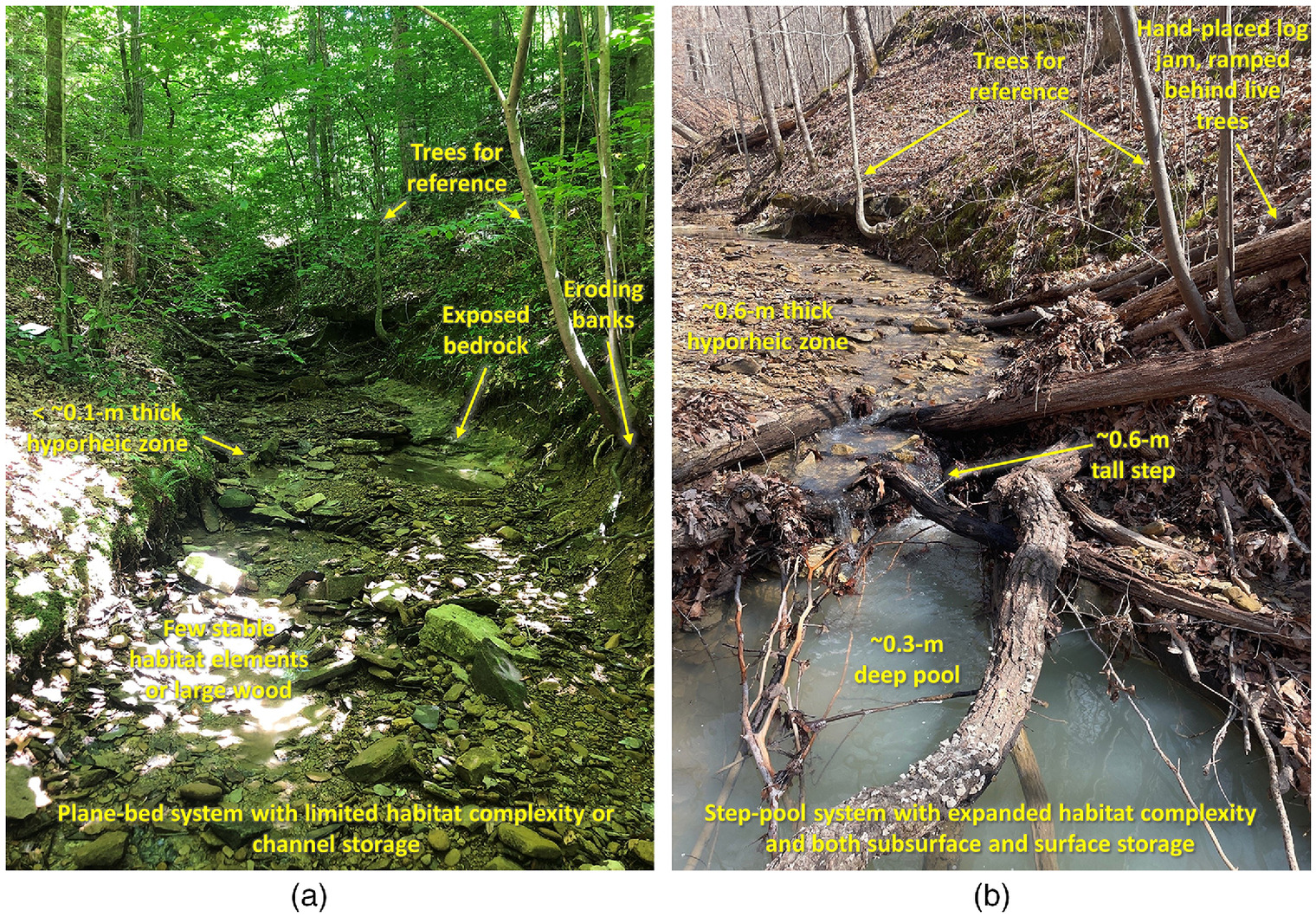
Installation of wood in first- to third-order streams can therefore be one of the most cost-effective restoration strategies to both improve channel habitat at reach scales (e.g., Cheney et al. 2019; Harman et al. 2012) and promote hyporheic and channel storage that supports hydrologic restoration at network scales (Hawley 2018). The strategy may be especially appropriate in streams with forested riparian zones to preclude the need for importing wood from off-site. Furthermore, by placing wood by hand as opposed to heavy equipment, the approach reduces the expense and hassle of revegetation and reforestation that are associated with more common stream restoration strategies that rely on earth-moving and regrading. The key with hand-placed log structures is ensuring that they are anchored in ways that avoid floating, such as by ramping logs out of the channel and anchoring them next to live trees (sensu, Davidson et al. 2015, Fig. 1). Exceptionally long key logs can also be added by felling select trees, which can also help to reduce the floating risk of smaller pieces that are light enough to place by hand. Low-tech wood installations can be extremely low cost: $35 per meter of channel for two recent grant-funded demonstration/training projects by Sustainable Streams compared with per meter for conventional stream restoration via heavy equipment (Hawley et al. 2017), and hand-placed installations would be expected to become even more economical, as field technicians gain more experience and reduce the need for professional guidance (e.g., $5.75 per meter, EPRI 2021).
Abbe and Montgomery (1996) noted the ability of individual key logs to trap additional wood and form jams that can be stable for decades or even centuries in large rivers. Blauch and Jefferson (2019) also documented a negative association between the abundance of natural wood in urban streams and wood mobility. Using insights from studies of natural jams, Abbe et al. (1997) pioneered the approach of engineering log jams to simulate natural jams and documented their stability, wood accumulation, and habitat creation after experiencing a 20-year flood five weeks after installing three large jams on a 195 m wide river draining , which was formerly experiencing substantial bank erosion. Our own experience with ca. 650 key log installations is consistent with these previous studies in that the more wood that is placed in channels along forested riparian zones, the more likely that a poorly anchored log will get caught in other jams, reducing the risk for unwanted downstream transport. Acknowledging the need to remove channel-spanning jams from culverts, bridges, and recreational river segments to maintain public safety, discontinued wood removal and installation of intentional jams in upstream reaches can help to reduce such downstream maintenance burdens by trapping wood loads in upstream portions of the network.
Ultimately, the largest driver of the natural wood regime is a forested riparian zone (Wohl et al. 2019), underscoring the value of including riparian reforestation in utility stewardship portfolios. Not only are forested riparian zones critical at providing a sustainable supply of future in-stream wood, but the increased shade can also mitigate the effects of high air and water temperature on thermal regimes (Rutherford et al. 2004), which can help preserve cooling efficiency at downstream power generation plants among other cobenefits. Furthermore, the wood associated with forested riparian zones and hand-placed log structures within headwater channels can provide stable emergent substrate for macroinvertebrates (Cheney et al. 2019), enhanced food webs, and a carbon source for denitrification (Baker et al. 2011), which can help ameliorate the adverse water quality effects of changing surface water conditions and provide direct habitat and energy benefits to the aquatic ecosystem. Another cobenefit of riparian reforestation is the associated carbon sequestration (Nowak and Crane 2002), making reforestation a particularly appealing management strategy given that it can help to mitigate climate change while at the same time benefiting aquatic ecosystems and downstream utilities.
Floodplain Wetlands
If one is considering large investments in the construction of new SCMs, floodplains are by far the most cost-effective location, with one recent study finding better than a cost–benefit ratio for floodplain land acquisition (Johnson et al. 2020). As noted, many North American floodplains have up to 1 to 2 m of postsettlement alluvium occupying space in valley bottoms (Wohl and Merritts 2007), which could otherwise be available for water storage, off-channel habitat, energy dissipation, and water quality processes. Preliminary analyses suggest that the cumulative amount of floodplain volume that is being occupied by postsettlement alluvium in large river basins may be on the same order of magnitude as the total storage capacity of their flood control reservoirs. For example, the 100-year flood zone in the Great Miami River watershed in Southwest Ohio has of floodplain area. Prior to European settlement, assuming the floodplain was 1.5 m lower than present day would correspond to of additional space within the floodplain for important ecological services such as more frequent floodplain inundation, energy dissipation, and habitat connectivity. Acknowledging the differences between transient floodplain storage and reservoir storage, for relative comparison, the five flood control reservoirs managed by the Miami Conservancy District (Ohio) provide a total of in storage volume (MCD 2018).
Removing just a fraction of the postsettlement alluvium from river floodplains could provide multiple benefits to both utilities and riverine ecosystems. First, the hydraulic connections between the river and the floodplain wetland can be optimized to begin to offload flow just prior to reaching the critical discharge for streambed erosion (Hawley and Vietz 2016), thereby using the floodplain storage to divert flows that would otherwise contribute to channel erosion. Second, restored floodplain wetlands can contribute to decreases in flood depths during floodplain-inundating events (Sustainable Streams 2019). Third, the vegetated surfaces and floodplain sinks can help to improve water quality by trapping sediment and adsorbed contaminants and assimilating nutrients during high-flow events that tend to carry the majority of the sediment and nutrient loads in a given network (Preisendanz et al. 2021). For example, several studies have found that oxbows and floodplain wetlands tend to be more retentive of nitrogen than floodplains that lack such features (Harrison et al. 2011, 2012; Mayer et al. 2022). Fourth, restored floodplain wetlands can also incorporate off-channel wintering holes that can be important rearing habitats for sensitive and endangered fishes (e.g., Górski et al. 2014; Limm and Marchetti 2009), making them critical conservation areas (Stark 2013).
Floodplain wetland restoration therefore has the potential to bring together large groups of diverse stakeholders and funding sources due to the numerous benefits that they can provide. As a changing climate creates more frequent floods, floodplains may become even less viable for other uses such as agriculture or development, making the strategy more feasible in terms of property access. Floodplain restoration and land use planning in such coupled human and natural systems could benefit from the CHANS framework (Moritz et al. 2016).
Excavation costs are considerable on any new SCM; however, floodplains are often the most efficient location in which to create new storage because every bucket of excavation coincides with an equal volume of expanded storage, whereas an open field in an upland environment may need to be excavated several meters prior to being able to intercept and offload flow from the stormwater system via gravity flow connections. Additionally, haul-off costs may be substantially reduced or even eliminated because floodplain soils tend to be high quality, incentivizing topsoil and landscaping companies to provide competitive prices to have access to the soil for beneficial reuse. For example, the unit cost from the winning bidder for a recent project by the Miami Park District and the US Fish and Wildlife Service in Troy, Ohio, was more than five times lower than typical on-site earthmoving costs due to the desirability of reusing the soil for another project by the winning contractor. Further, depending on sediment types and loads, upstream groundcover, and other factors, floodplain wetlands can be expected to have relatively little maintenance needs over their design life. For example, suspended sediment concentrations and types (i.e., proportion of sand, silt, and clay) in the Great Miami River (USGS 1978) combined with inundation frequencies correspond to sediment deposition rates of to 1.5 m per century suggesting that a 1.5 m deep wetland would be expected to fill in over approximately one to five centuries if sediment loads and distributions remain comparable with the previously collected data. The design life estimate for individual wetlands should be calibrated with local data and adjusted based on observed sediment aggradation rates in the constructed floodplain wetlands on a given river system.
In sum, construction of floodplain wetlands can be one of the most efficient SCMs involving new construction because they involve little else other than the earthwork costs associated with excavating large volumes of soil from the floodplain and relocating the soil to areas outside of the floodplain. This is especially true when they can be located in unforested floodplains on properties that do not require land acquisition costs (e.g., public lands formerly leased for hay or crop production). In comparison with other SCMs, which can include numerous other cost items such as gravel, underdrains, soil amendments, and infrastructure to collect and route the stormwater to the SCM, floodplain wetlands are likely to have orders of magnitude lower costs. For example, in a recent conceptual study of three large river basins using USGS gage data and a of 0.45x the two-year peak discharge () after Hawley and Vietz (2016) assuming streambeds composed of coarse gravels/small cobbles, EPRI (2021) documented a reduction in channel erosion frequency for in floodplain wetlands in a watershed, and a 70% reduction in channel erosion frequency for just in floodplain wetlands in a separate watershed. These conceptual-level costs suggest a potential for meaningful reductions in channel erosion for just to of drainage managed, which is substantially less than construction of other SCMs that can range up to of managed drainage area in urban settings with tight spaces and high land acquisition costs (King County 2013). Although specific costs will vary by setting and management goals, similar cost advantages would be expected in other watersheds due to the underlying simplicity of floodplain wetlands combined with their ability to easily intercept large volumes of flow compared with new construction of other SCMs.
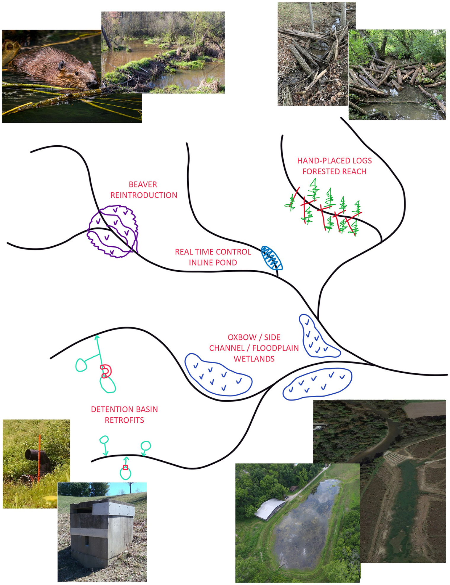
Synthesis
Society’s infrastructure, including electric power utilities, is facing numerous risks associated with the altered streamflow regimes of a changing climate. Individual adaptive strategies may be necessary in some cases; however, cost-effective watershed-scale strategies may ultimately be the most sustainable approach to holistic risk mitigation. Retrofits of existing detention ponds, restoration of in-channel wood, beaver reintroduction, and floodplain wetlands (Fig. 2) might provide more comprehensive risk mitigation than conventional strategies and have greater environmental and socioeconomic cobenefits. Costs will vary by setting and goals; however, utilities could begin by adopting low-cost strategies on their own property, such as riparian reforestation, beaver reintroductions (or discontinued extirpation), or pond retrofits. For example, preliminary analysis by Sustainable Streams, American Electric Power, and EPRI in 2018 for a formerly mined watershed, flows from 96% of the watershed could be restored via just three interventions, i.e., two retrofits of existing ponds and one floodplain wetland, at a preliminary cost of just of managed drainage area (EPRI 2021). Scaling up to much larger watersheds on the order of to , EPRI (2021) documented similar cost-effectiveness ratios using beaver reintroductions and floodplain wetlands to install enough new storage to appreciably reduce the frequency of channel-eroding events [ranging to of managed drainage to create 10% to 90% reductions in the frequency of channel-eroding events based on USGS gage analysis and after Hawley and Vietz (2016)]. Although actual costs will vary, these order-of-magnitude estimates are intended to underscore the relative cost-effectiveness of the strategies highlighted herein, with the goal of helping utilities to tailor watershed-scale hydrologic restoration that can be cost-viable across both large and small watersheds. Furthermore, such watershed-scale management efforts aimed at restoring a more natural flow regime can have widespread appeal to a broader set of stakeholders and funding agencies, providing the potential to leverage utility dollars as matching funds for grants, which can encourage even more stakeholder collaboration and greater implementation. These watershed-scale projects could lead to potential partnerships with nonprofit organizations, stormwater management districts, soil and water conservation districts, and county/state/federal organizations, which can help further the mission of creating surface water, infrastructure, and ecosystem resilience in the face of a changing climate.
Data Availability Statement
No data, models, or code were generated or used during the study.
Acknowledgments
This manuscript was supported in part by EPRI. The authors would like to thank Nora Korth (Sustainable Streams) who contributed to preliminary analysis and Nalini Rao (EPRI), Tim Lohner (American Electric Power), Matt Montz (Southern Company), and Justin Walters (Southern Company) who provided helpful reviews of an earlier version of this manuscript. Three anonymous reviewers and the associate editor also provided highly constructive reviews that substantially strengthened the manuscript. We also thank Donnie Knight (USFWS), John McManus and Becky McClatchy (Clermont Co. Soil and Water District), Chris Nietch (USEPA), and Mark Jacobs (Boone Co. Conservation District) who spearheaded several floodplain wetland implementation efforts that provided valuable insights for this manuscript.
References
Abbe, T. B., and D. R. Montgomery. 1996. “Large woody debris jams, channel hydraulics and habitat formation in large rivers.” Regul. Rivers: Res. Manage. 12 (2–3): 201–221. https://doi.org/10.1002/(SICI)1099-1646(199603)12:2/3%3C201::AID-RRR390%3E3.0.CO;2-A.
Abbe, T. B., D. R. Montgomery, and C. Petroff. 1997. “Design of stable in-channel wood debris structures for bank protection and habitat restoration: An example from the Cowlitz River, WA.” In Proc., Conf. on Management Disturbed by Channel Incision, 809–815. Oxford, MS: Univ. of Mississippi.
Abt, S. R., C. I. Thornton, B. A. Scholl, and T. R. Bender. 2013. “Evaluation of overtopping riprap design relationships.” JAWRA J. Am. Water Resour. Assoc. 49 (4): 923–937. https://doi.org/10.1111/jawr.12074.
Ameli, A. A., and I. F. Creed. 2019. “Groundwaters at risk: Wetland loss changes sources, lengthens pathways, and decelerates rejuvenation of groundwater resources.” J. Am. Water Resour. Assoc. 55 (2): 294–306. https://doi.org/10.1111/1752-1688.12690.
Azrina, M. Z., C. K. Yap, A. R. Ismail, A. Ismail, and S. G. Tan. 2006. “Anthropogenic impacts on the distribution and biodiversity of benthic macroinvertebrates and water quality of the Langat River, Peninsular Malaysia.” Ecotoxicol. Environ. Saf. 64 (3): 337–347. https://doi.org/10.1016/j.ecoenv.2005.04.003.
Baker, D. W., B. P. Bledsoe, and J. Mueller Price. 2011. “Stream nitrate uptake and transient storage over a gradient of geomorphic complexity, north-central Colorado,USA.” Hydrol. Processes 26 (21): 3241–3252. https://doi.org/10.1002/hyp.8385.
Bartos, M., B. Wong, and B. Kerkez. 2018. “Open storm: A complete framework for sensing and control of urban watersheds.” Environ. Sci. Water Res. Technol. 4 (3): 346–358.
Bell, C. D., J. Wolfand, C. Panos, A. Bhaskar, R. Gilliom, T. Hogue, K. G. Hopkins, and A. J. Jefferson. 2020. “Stormwater control impacts on runoff volume and peak flow: A meta-analysis of watershed modelling studies.” Hydrol. Processes 34 (14): 3134–3152. https://doi.org/10.1002/hyp.13784.
Bernhardt, E. S., et al. 2005. “Synthesizing US river restoration efforts.” Science 308 (5722): 636–637. https://doi.org/10.1126/science.1109769.
Blauch, G. A., and A. J. Jefferson. 2019. “If a tree falls in an urban stream, does it stick around? Mobility, characteristics, and geomorphic influence of large wood in urban streams in Northeastern Ohio, USA.” Geomorphology 337 (15): 1–14. https://doi.org/10.1016/j.geomorph.2019.03.033.
Bledsoe, B. P. 2002. “Stream erosion potential associated with stormwater management strategies.” J. Water Resour. Plann. Manage. 128 (6): 451–455. https://doi.org/10.1061/(ASCE)0733-9496(2002)128:6(451).
Bledsoe, B. P., D. W. Baker, P. A. Nelson, T. Rosburg, J. Sholtes, and T. R. Stroth. 2016. Design hydrology for stream restoration and channel stability at stream crossings. Washington, DC: Transportation Research Board.
Bledsoe, B. P., and C. C. Watson. 2001. “Logistic analysis of channel pattern thresholds: Meandering, braiding, and incising.” Geomorphology 38 (3–4): 281–300. https://doi.org/10.1016/S0169-555X(00)00099-4.
Booth, D. B. 1990. “Stream-channel incision following drainage-basin urbanization.” J. Am. Water Resour. Assoc. 26 (3): 407–417. https://doi.org/10.1111/j.1752-1688.1990.tb01380.x.
Booth, D. B., and C. J. Fischenich. 2015. “A channel evolution model to guide sustainable urban stream restoration.” Area 47 (4): 408–421. https://doi.org/10.1111/area.12180.
Booth, D. B., and C. R. Jackson. 1997. “Urbanization of aquatic systems: Degradation thresholds, stormwater detection, and the limits of mitigation.” J. Am. Water Resour. Assoc. 33 (5): 1077–1090. https://doi.org/10.1111/j.1752-1688.1997.tb04126.x.
Buffington, J. M., T. E. Lisle, R. D. Woodsmith, and S. Hilton. 2002. “Controls on the size and occurrence of pools in coarse-grained forest rivers.” River Res. Appl. 18 (6): 507–531. https://doi.org/10.1002/rra.693.
Burchsted, D., M. Daniels, R. Thorson, and J. Vokoun. 2010. “The river discontinuum: Applying beaver modifications to baseline conditions for restoration of forested headwaters.” Bioscience 60 (11): 908–922. https://doi.org/10.1525/bio.2010.60.11.7.
Carpenter, J. F., B. Vallet, G. Pelletier, P. Lessard, and P. A. Vanrolleghem. 2014. “Pollutant removal efficiency of a retrofitted stormwater detention pond.” Water Qual. Res. J. Can. 49 (2): 124–134. https://doi.org/10.2166/wqrjc.2013.020.
Cheney, K. N., A. H. Roy, R. F. Smith, and R. E. DeWalt. 2019. “Effects of stream temperature and substrate type on emergence patterns of plecoptera and trichoptera from northeastern United States headwater streams.” Environ. Entomol. 48 (6): 1349–1359. https://doi.org/10.1093/ee/nvz106.
Chin, A. 2006. “Urban transformation of river landscapes in a global context.” Geomorphology 79 (3–4): 460–487. https://doi.org/10.1016/j.geomorph.2006.06.033.
Chin, A., R. Gidley, L. Tyner, and K. J. Gregory. 2017. “Adjustment of dryland stream channels over four decades of urbanization.” Anthropocene 20 (Dec): 24–36. https://doi.org/10.1016/j.ancene.2017.11.001.
Chini, C. M., M. Konar, and A. S. Stillwell. 2017. “Direct and indirect urban water footprints of the United States.” Water Resour. Res. 53 (1): 316–327. https://doi.org/10.1002/2016WR019473.
Collins, B. D., and D. R. Montgomery. 2002. “Forest development, wood jams, and restoration of floodplain rivers in the Puget lowland, Washington.” Restor. Ecol. 10 (2): 237–247. https://doi.org/10.1046/j.1526-100X.2002.01023.x.
CRS (Congressional Research Service). 2019. The endangered species act and climate change: Selected legal issues. Washington, DC: CRC.
Dahl, T. E. 1990. Wetlands—Losses in the United States, 1780’s to 1980’s. Washington, DC: Fish and Wildlife Service.
Davidson, N. C. 2014. “How much wetland has the world lost? Long-term and recent trends in global wetland area.” Mar. Freshwater Res. 65 (10): 934–941. https://doi.org/10.1071/MF14173.
Davidson, S. L., L. G. MacKenzie, and B. C. Eaton. 2015. “Large wood transport and jam formation in a series of flume experiments.” Water Resour. Res. 51 (12): 10065–10077. https://doi.org/10.1002/2015WR017446.
DeNooyer, T. A., J. M. Peschel, Z. Zhang, and A. Stillwell. 2016. “Integrating water resources and power generation: The energy–water nexus in Illinois.” Appl. Energy 162 (Jan): 363–371. https://doi.org/10.1016/j.apenergy.2015.10.071.
Dijkstra, J. A., K. L. Buckman, D. Ward, D. W. Evans, M. Dionne, and C. Y. Chen. 2013. “Experimental and natural warming elevates mercury concentrations in estuarine fish.” PLoS One 8 (3): e58401. https://doi.org/10.1371/journal.pone.0058401.
Eaton, W. M., et al. 2021. “A conceptual framework for social, behavioral, and environmental change through stakeholder engagement in water resource management.” Soc. Nat. Resour. 34 (8): 1111–1132. https://doi.org/10.1080/08941920.2021.1936717.
EPRI (Electric Power Research Institute). 2017. Alternative water supplies for power generation, 3002012045. Palo Alto, CA: EPRI.
EPRI (Electric Power Research Institute). 2020a. Evaluation of hydrological models for climate-based assessments: Review of existing hydrological and water quality models, 3002019495. Palo Alto, CA: EPRI.
EPRI (Electric Power Research Institute). 2020b. Potential water-related risks to the electric power industry associated with changing surface water conditions, 3002017809. Palo Alto, CA: EPRI.
EPRI (Electric Power Research Institute). 2020c. Program on technology innovation: Minimizing risks to the electric power industry from changing surface water conditions, 3002017808. Palo Alto, CA: EPRI.
EPRI (Electric Power Research Institute). 2021. Conceptual watershed-scale opportunities to minimize risks of changing surface water conditions—A pilot analysis of three River Basins, 3002021683. Palo Alto, CA: EPRI.
Fairfax, E., and E. E. Small. 2018. “Using remote sensing to assess the impact of Beaver damming on riparian evapotranspiration in an arid landscape.” Ecohydrology 11 (7): e1993. https://doi.org/10.1002/eco.1993.
Fairfax, E., and A. Whittle. 2020. “Smokey the Beaver: Beaver-dammed riparian corridors stay green during wildfire throughout the Western United States.” Ecol. Appl. 30 (8): e02225. https://doi.org/10.1002/eap.2225.
Ficklin, D. L., I. T. Stewart, and E. P. Maurer. 2013. “Effects of climate change on stream temperature, dissolved oxygen, and sediment concentration in the Sierra Nevada in California.” Water Resour. Res. 49 (5): 2765–2782. https://doi.org/10.1002/wrcr.20248.
Gillespie, R., and J. Bennett. 2022. “Willingness to pay for the outcomes of improved stormwater management.” Urban Water J. 19 (9): 900–910. https://doi.org/10.1080/1573062X.2022.2102511.
Goldfarb, B. 2018. Eager: The surprising, secret life of beavers and why thy matter, 286. White River Junction, VT: Chelsea Green Publishing.
Gomi, T., R. C. Sidle, M. D. Bryant, and R. D. Woodsmith. 2001. “The characteristics of woody debris and sediment distribution in headwater streams, southeastern Alaska.” Can. J. For. Res. 31 (8): 1386–1399. https://doi.org/10.1139/x01-070.
Górski, K., K. J. Collier, D. P. Hamilton, and B. J. Hicks. 2014. “Effects of flow on lateral interactions of fish and shrimps with off-channel habitats in a large river-floodplain system.” Hydrobiologia 729 (1): 161–174. https://doi.org/10.1007/s10750-012-1352-1.
Grantham, T. E., J. H. Matthews, and B. P. Bledsoe. 2019. “Shifting currents: Managing freshwater systems for ecological resilience in a changing climate.” Water Secur. 8 (Dec): 100049. https://doi.org/10.1016/j.wasec.2019.100049.
Grubert, E., and K. T. Sanders. 2018. “Water use in the United States energy system: A national assessment and unit process inventory of water consumption and withdrawals.” Environ. Sci. Technol. 52 (11): 6695–6703. https://doi.org/10.1021/acs.est.8b00139.
Grubert, E. A., F. C. Beach, and M. E. Webber. 2012. “Can switching fuels save water? A life cycle quantification of freshwater consumption for Texas coal- and natural gas-fired electricity.” Environ. Res. Lett. 7 (4): 045801. https://doi.org/10.1088/1748-9326/7/4/045801.
Gulbin, S., A. P. Kirilenko, G. Kharel, and X. Zhang. 2019. “Wetland loss impact on long term flood risks in a closed watershed.” Environ. Sci. Policy 94 (Apr): 112–122. https://doi.org/10.1016/j.envsci.2018.12.032.
Harman, W. A., R. Starr, M. Carter, K. Tweedy, M. Clemmons, K. Suggs, and C. Miller. 2012. A function-based framework for stream assessment and restoration projects. Washington, DC: USEPA.
Harrison, M. D., P. M. Groffman, P. M. Mayer, and S. S. Kaushal. 2012. “Nitrate removal in two relict oxbow urban wetlands: A 15N mass-balance approach.” Biogeochemistry 111 (1–3): 647–660. https://doi.org/10.1007/s10533-012-9708-1.
Harrison, M. D., P. M. Groffman, P. M. Mayer, S. S. Kaushal, and T. A. Newcomer. 2011. “Denitrification in alluvial wetlands in an urban landscape.” J. Environ. Qual. 40 (2): 634–646. https://doi.org/10.2134/jeq2010.0335.
Hawley, R. J. 2018. “Making stream restoration more sustainable: A geomorphically, ecologically, and socioeconomically principled approach to bridge the practice with the science.” Bioscience 68 (7): 517–528. https://doi.org/10.1093/biosci/biy048.
Hawley, R. J. 2022. “Expanding catchment-scale hydrologic restoration in suburban watersheds via stream mitigation crediting—A Northern Kentucky (USA) case study.” Urban Ecosyst. 25 (1): 133–147. https://doi.org/10.1007/s11252-021-01139-x.
Hawley, R. J., and B. P. Bledsoe. 2013. “Channel enlargement in semi-arid suburbanizing watersheds: A southern California case study.” J. Hydrol. 496 (Jul): 17–30. https://doi.org/10.1016/j.jhydrol.2013.05.010.
Hawley, R. J., B. P. Bledsoe, E. D. Stein, and B. E. Haines. 2012. “Channel evolution model of semiarid stream response to urban-induced hydromodification.” J. Am. Water Resour. Assoc. 48 (4): 722–744. https://doi.org/10.1111/j.1752-1688.2012.00645.x.
Hawley, R. J., J. A. Goodrich, N. L. Korth, C. J. Rust, E. V. Fet, C. Frye, K. R. MacMannis, M. S. Wooten, and R. Sinha. 2017. “Detention outlet retrofit device improves the functionality of existing detention basins by reducing erosive flows in receiving channels.” J. Am. Water Resour. Assoc. 53 (5): 1032–1047. https://doi.org/10.1111/1752-1688.12548.
Hawley, R. J., J. A. Goodrich, and K. R. MacMannis. 2019. Detain H2O - Detention pond retrofit device. US Serial number 61/958,027 10,316,506, and issued June 11, 2019. Washington, DC: US Patent and Trademark Office.
Hawley, R. J., and K. R. MacMannis. 2019. “Tree roots as a dominant agent of streambed habitat, profile pattern, and grade control.” Geomorphology 343 (Oct): 81–91. https://doi.org/10.1016/j.geomorph.2019.06.021.
Hawley, R. J., K. R. MacMannis, and M. S. Wooten. 2013. “How poor stormwater practices are shortening the life of our nation’s infrastructure--recalibrating stormwater management for stream channel stability and infrastructure sustainability.” In Proc., World Environmental and Water Resources Congress. Reston, VA: ASCE.
Hawley, R. J., K. R. MacMannis, M. S. Wooten, E. V. Fet, and N. L. Korth. 2020. “Suburban stream erosion rates in northern Kentucky exceed reference channels by an order of magnitude and follow predictable trajectories of channel evolution.” Geomorphology 352 (Mar): 106998. https://doi.org/10.1016/j.geomorph.2019.106998.
Hawley, R. J., K. Russell, and K. Taniguchi-Quan. 2022. “Restoring geomorphic integrity in urban streams via mechanistically-based storm water management: Minimizing excess sediment transport capacity.” Urban Ecosyst. 25 (4): 1247–1264. https://doi.org/10.1007/s11252-022-01221-y.
Hawley, R. J., and G. J. Vietz. 2016. “Addressing the urban stream disturbance regime.” Freshwater Sci. 35 (1): 278–292. https://doi.org/10.1086/684647.
Hawley, R. J., M. S. Wooten, K. R. MacMannis, and E. V. Fet. 2016. “When do macroinvertebrate communities of reference streams resemble urban streams? The biological relevance of Qcritical.” Freshwater Sci. 35 (3): 778–794. https://doi.org/10.1086/687808.
Hidalgo, H. G., et al. 2009. “Detection and attribution of streamflow timing changes to climate change in the western United States.” J. Clim. 22 (13): 3838–3855. https://doi.org/10.1175/2009JCLI2470.1.
Horton, R. E. 1945. “Erosional development of streams and their drainage basins: Hydrophysical approach to quantitative morphology.” Geol. Soc. Am. Bull. 56 (3): 275–370. https://doi.org/10.1130/0016-7606(1945)56[275:EDOSAT]2.0.CO;2.
IPCC (Intergovernmental Panel on Climate Change). 2021. Climate change 2021: The physical science basis. Working group I. Geneva: IPCC.
Jaeger, K. L., J. D. Olden, and N. A. Pelland. 2014. “Climate change poised to threaten hydrologic connectivity and endemic fishes in dryland streams.” Proc. Natl. Acad. Sci. 111 (38): 13894–13899. https://doi.org/10.1073/pnas.1320890111.
Jamison, P. 2015. “Army Corps board approves $1.3-billion L.A. River restoration proposal.” Los Angeles Times, July 1, 2015.
Johnson, K. A., O. E. Wing, P. D. Bates, J. Fargione, T. Kroeger, W. D. Larson, C. C. Sampson, and A. M. Smith. 2020. “A benefit–cost analysis of floodplain land acquisition for US flood damage reduction.” Nat. Sustainability 3 (1): 56–62. https://doi.org/10.1038/s41893-019-0437-5.
Junquera, R., and T. Cmar. 2016. “Agreement reached over water discharge dispute at LG&E’s Mill Creek Power plant.” Accessed December 30, 2019. https://content.sierraclub.org/press-releases/2016/09/agreement-reached-over-water-discharge-dispute-lge-s-mill-creek-power-plant.
Karran, D. J., C. J. Westbrook, J. M. Wheaton, C. A. Johnston, and A. Bedard-Haughn. 2017. “Rapid surface-water volume estimations in beaver ponds.” Hydrol. Earth Syst. Sci. 21 (2): 1039–1050. https://doi.org/10.5194/hess-21-1039-2017.
Kemp, D. B., P. M. Sadler, and V. Vanacker. 2020. “The human impact on North American erosion, sediment transfer, and storage in a geologic context.” Nat. Commun. 11 (1): 6012. https://doi.org/10.1038/s41467-020-19744-3.
Khan, D., and Z. Ahmad. 2011. “Stabilization of angular-shaped riprap under overtopping flows.” World Acad. Sci. Eng. Technol. 59 (Nov): 1153–1157.
King County. 2013. Development of a stormwater retrofit plan for water resources inventory area 9: SUSTAIN model pilot study. Seattle: King County, Dept. of Natural Resources and Parks.
Kline, J. D., E. M. White, A. P. Fischer, M. M. Steen-Adams, S. Charnley, C. S. Olsen, T. A. Spies, and J. D. Bailey. 2017. “Integrating social science into empirical models of coupled human and natural systems.” Ecol. Soc. 22 (3): 25. https://doi.org/10.5751/ES-09329-220325.
Kondolf, G. M. 2006. “River restoration and meanders.” Ecol. Soc. 11 (2): 42–59. https://doi.org/10.5751/ES-01795-110242.
Kuckro, R. 2014. Receding lake mead poses challenges to Hoover Dam’s power output. Washington, DC: Environment & Energy Publishing, LLC.
Kundzewicz, Z. W., V. Krysanova, R. E. Benestad, Ø. Hov, M. Piniewski, and I. M. Otto. 2018. “Uncertainty in climate change impacts on water resources.” Environ. Sci. Policy 79 (Jan): 1–8.
Lammers, R. W., L. Miller, and B. P. Bledsoe. 2022. “Effects of design and climate on bioretention effectiveness for watershed-scale hydrologic benefits.” J. Sustainable Water Built Environ. 8 (4): 04022011. https://doi.org/10.1061/JSWBAY.0000993.
Leopold, L. B., R. Huppman, and A. Miller. 2005. “Geomorphic effects of urbanization in forty-one years of observation.” Proc. Am. Philos. Soc. 149 (3): 349–371.
Limm, M. P., and M. P. Marchetti. 2009. “Juvenile Chinook salmon (Oncorhynchus tshawytscha) growth in off-channel and main-channel habitats on the Sacramento River, CA using otolith increment widths.” Environ. Biol. Fishes 85 (2): 141–151. https://doi.org/10.1007/s10641-009-9473-8.
Liu, J., et al. 2007. “Coupled human and natural systems.” AMBIO: J. Hum. Environ. 36 (8): 639–649. https://doi.org/10.1579/0044-7447(2007)36[639:CHANS]2.0.CO;2.
Logan, L. H., R. S. Gupta, A. Ando, C. Suski, and A. S. Stillwell. 2021. “Quantifying tradeoffs between electricity generation and fish populations via population habitat duration curves.” Ecol. Modell. 440 (Jan): 109373. https://doi.org/10.1016/j.ecolmodel.2020.109373.
Logan, L. H., and A. S. Stillwell. 2018. “Probabilistic assessment of aquatic species risk from thermoelectric power plant effluent: Incorporating biology into the energy-water nexus.” Appl. Energy 210 (Jan): 434–450. https://doi.org/10.1016/j.apenergy.2017.09.027.
Macknick, J., R. Newmark, G. Heath, and K. C. Hallett. 2012. “Operational water consumption and withdrawal factors for electricity generating technologies: A review of existing literature.” Environ. Res. Lett. 7: 1–10.
MacRae, C. R. 1997. “Experience from morphological research on Canadian streams: Is the control of the two-year frequency runoff event the best basis for stream channel protection?” In Effects of watershed development and management of aquatic ecosystems, edited by L. A. Roesner, 144–162. Reston, VA: ASCE.
Marston, R. A. 1982. “The geomorphic significance of log steps in forest streams.” Ann. Assoc. Am. Geogr. 72 (1): 99–108. https://doi.org/10.1111/j.1467-8306.1982.tb01386.x.
Mayer, P. M., M. J. Pennino, and T. A. Newcomer-Johnson. 2022. “Long-term assessment of floodplain reconnection as a stream restoration approach for managing nitrogen in groundwater and surface water.” Urban Ecosyst. 25 (3): 879–907. https://doi.org/10.1007/s11252-021-01199-z.
MCD (Miami Conservancy District). 2018. Our region’s water, 12. Dayton, OH: MCD.
Milly, P. C., K. A. Dunne, and A. V. Vecchia. 2005. “Global pattern of trends in streamflow and water availability in a changing climate.” Nature 438 (7066): 347. https://doi.org/10.1038/nature04312.
Moritz, M., et al. 2016. “Studying the Logone floodplain, Cameroon, as a coupled human and natural system.” Afr. J. Aquat. Sci. 41 (1): 99–108. https://doi.org/10.2989/16085914.2016.1143799.
Naiman, R. J., C. A. Johnston, and J. C. Kelley. 1988. “Alteration of North American streams by beaver.” Bioscience 38 (11): 753–762. https://doi.org/10.2307/1310784.
Nakamura, F., and F. J. Swanson. 1993. “Effects of coarse woody debris on morphology and sediment storage of a mountain stream system in western Oregon.” Earth Surf. Processes Landforms 18 (1): 43–61. https://doi.org/10.1002/esp.3290180104.
Nelson, K. C., and M. A. Palmer. 2007. “Stream temperature surges under urbanization and climate change: Data, models, and responses.” JAWRA J. Am. Water Resour. Assoc. 43 (2): 440–452. https://doi.org/10.1111/j.1752-1688.2007.00034.x.
Nowak, D. J., and D. E. Crane. 2002. “Carbon storage and sequestration by urban trees in theUSA.” Environ. Pollut. 116 (3): 381–389. https://doi.org/10.1016/S0269-7491(01)00214-7.
Nugent, C. 2022. “Why is Paris uncovering a river it buried a century ago?” Time, February 14, 2022.
Nyssen, J., J. Pontzeele, and P. Billi. 2011. “Effect of beaver dams on the hydrology of small mountain streams: Example from the Chevral in the Ourthe Orientale basin, Ardennes, Belgium.” J. Hydrol. 402 (1–2): 92–102. https://doi.org/10.1016/j.jhydrol.2011.03.008.
Oldfather, M. F., M. M. Kling, S. N. Sheth, N. C. Emery, and D. D. Ackerly. 2020. “Range edges in heterogeneous landscapes: Integrating geographic scale and climate complexity into range dynamics.” Global Change Biol. 26 (3): 1055–1067. https://doi.org/10.1111/gcb.14897.
Papangelakis, E., B. MacVicar, and P. Ashmore. 2019. “Bedload sediment transport regimes of semi-alluvial rivers conditioned by urbanization and stormwater management.” Water Resour. Res. 55 (12): 10565–10587. https://doi.org/10.1029/2019WR025126.
Parola, A. C., D. J. Hagerty, and S. Kamojjala. 1998. Highway infrastructure damage caused by the 1993 Upper Mississippi River basin flooding. Washington, DC: Transportation Research Board.
Peer, R. A. M., E. Grubert, and K. T. Sanders. 2019. “A regional assessment of the water embedded in the US electricity system.” Environ. Res. Lett. 14 (8): 084014. https://doi.org/10.1088/1748-9326/ab2daa.
Perica, S., S. Pavlovic, M. St. Laurent, C. Trypaluk, D. Unruh, and O. Wilhite. 2018. “NOAA Atlas 14: Precipitation-frequency Atlas of the United States.” Accessed December 30, 2019. https://www.nws.noaa.gov/oh/hdsc/PF_documents/Atlas14_Volume11.pdf.
Pfeiffer, A., and E. E. Wohl. 2018. “Where does wood most effectively enhance storage? network-scale distribution of sediment and organic matter stored by instream wood.” Geophys. Res. Lett. 45 (1): 194–200. https://doi.org/10.1002/2017GL076057.
Plumb, B. D., W. K. Annable, P. J. Thompson, and M. A. Hassan. 2017. “The impact of urbanization on temporal changes in sediment transport in a gravel bed channel in Southern Ontario, Canada.” Water Resour. Res. 53 (10): 8443–8458. https://doi.org/10.1002/2016WR020288.
Plumb, B. D., C. Juez, W. K. Annable, C. W. McKie, and M. J. Franca. 2019. “The impact of hydrograph variability and frequency on sediment transport dynamics in a gravel-bed flume.” Earth Surf. Processes Landforms 45 (4): 816–830. https://doi.org/10.1002/esp.4770.
Poff, N. L., et al. 2010. “The ecological limits of hydrologic alteration (ELOHA): A new framework for developing regional environmental flow standards.” Freshwater Biol. 55 (1): 147–170. https://doi.org/10.1111/j.1365-2427.2009.02204.x.
Poff, N. L., J. D. Allan, M. B. Bain, J. R. Karr, K. L. Prestegaard, B. D. Richter, R. E. Sparks, and J. C. Stromberg. 1997. “The natural flow regime: A paradigm for conservation and restoration of river ecosystems.” Bioscience 47 (11): 769–784. https://doi.org/10.2307/1313099.
Pollock, M. M., T. J. Beechie, J. M. Wheaton, C. E. Jordan, N. Bouwes, N. Weber, and C. Volk. 2014. “Using beaver dams to restore incised stream ecosystems.” Bioscience 64 (4): 279–290. https://doi.org/10.1093/biosci/biu036.
Pollock, M. M., M. Heim, and D. Werner. 2003. “Hydrologic and geomorphic effects of beaver dams and their influence on fishes.” In The ecology and management of wood in World Rivers. Bethesda, MD: American Fisheries Society. https://doi.org/10.47886/9781888569568.ch11.
Preisendanz, H. E., T. L. Veith, Q. Zhang, and J. Shortle. 2021. “Temporal inequality of nutrient and sediment transport: A decision-making framework for temporal targeting of load reduction goals.” Environ. Res. Lett. 16 (1): 014005. https://doi.org/10.1088/1748-9326/abc997.
Records, R. M., M. Arabi, S. R. Fassnacht, W. G. Duffy, M. Ahmadi, and K. C. Hegewisch. 2014. “Climate change and wetland loss impacts on a western river’s water quality.” Hydrol. Earth Syst. Sci. 18 (11): 4509–4527. https://doi.org/10.5194/hess-18-4509-2014.
Rutherford, J. C., N. A. Marsh, P. M. Davies, and S. E. Bunn. 2004. “Effects of patchy shade on stream water temperature: How quickly do small streams heat and cool?” Mar. Freshwater Res. 55 (8): 737–748. https://doi.org/10.1071/MF04120.
Schumm, S. A., M. D. Harvey, and C. C. Watson. 1984. Incised channels: Morphology, dynamics, and control. Littleton, CO: Water Resources Publications.
Scoggins, M., et al. 2022. “Community-powered urban stream restoration: A vision for sustainable and resilient urban ecosystems.” Freshwater Sci. 41 (3): 404–419. https://doi.org/10.1086/721150.
Simon, A., and L. Klimetz. 2008. “Relative magnitudes and sources of sediment in benchmark watersheds of the conservation effects assessment project.” J. Soil Water Conserv. 63 (6): 504–522. https://doi.org/10.2489/jswc.63.6.504.
Smith, R. F., et al. 2016. “Urban stream renovation: Incorporating societal objectives to achieve ecological improvements.” Freshwater Sci. 35 (1): 364–379. https://doi.org/10.1086/685096.
Soar, P. J., and C. R. Thorne. 2001. Channel design for meandering rivers. Vicksburg, MS: USACE.
Stark, J. 2013. The Ohio River Basin fish habitat partnership strategic plan, 65. Dublin, OH: The Nature Conservancy.
Stephens, T. A., and B. P. Bledsoe. 2020. “Probabilistic mapping of flood hazards: Depicting uncertainty in streamflow, land use, and geomorphic adjustment.” Anthropocene 29 (Mar): 100231. https://doi.org/10.1016/j.ancene.2019.100231.
Stillwell, A., M. E. Clayton, and M. E. Webber. 2011. “Technical analysis of a river basin-based model of advanced power plant cooling technologies for mitigating water management challenges.” Environ. Res. Lett. 6 (3): 034015. https://doi.org/10.1088/1748-9326/6/3/034015.
Stocker, T. 2014. Climate change 2013: The physical science basis: Working Group I contribution to the Fifth assessment report of the Intergovernmental Panel on Climate Change. Cambridge, UK: Cambridge University Press.
Sustainable Streams. 2019. Floodplain habitat restoration project great Miami river hydrologic/hydraulic analysis memorandum. Louisville, KY: Sustainable Streams, LLC.
Sustainable Streams and US Fish and Wildlife Service. 2020. Sustainable watershed planning guidebook. Draft, Netherlands: US Fish and Wildlife Service.
Swain, D. L., B. Langenbrunner, J. D. Neelin, and A. Hall. 2018. “Increasing precipitation volatility in twenty-first-century California.” Nat. Clim. Change 8 (5): 427–433. https://doi.org/10.1038/s41558-018-0140-y.
Taniguchi, K. T., T. W. Biggs, E. J. Langendoen, C. Castillo, N. Gudino-Elizondo, Y. Yuan, and D. Linden. 2018. “Stream channel erosion in a rapidly urbanizing region of the US–Mexico border: Documenting the importance of channel hardpoints with structure-from-motion photogrammetry.” Earth Surf. Processes Landforms 43 (7): 1465–1477. https://doi.org/10.1002/esp.4331.
Taur, C. K., A. Faucett, G. Toth, F. C. Houston, J. M. Guerrero, and G. E. Oswald. 2019. Drainage criteria manual supplement 7. Austin, TX: City of Austin.
US EIA (US Energy Information Administration). 2018. “Some US electricity generating plants use dry cooling.” Accessed December 24, 2019. https://www.eia.gov/todayinenergy/detail.php?id=36773#.
USGS. 1978. Fluvial sediment in Ohio. Reston, VA: USGS.
van Vliet, M., J. Yearsley, F. Ludwig, S. Vogele, D. P. Lettenmaier, and P. Kabat. 2012. “Vulnerability of US and European electricity supply to climate change.” Nat. Clim. Change 2 (9): 676–681. https://doi.org/10.1038/nclimate1546.
van Vliet, M. T., D. Wiberg, S. Leduc, S. Leduc, and K. Riahi. 2016. “Power-generation system vulnerability and adaptation to changes in climate and water resources.” Nat. Clim. Change 6 (4): 375–380. https://doi.org/10.1038/nclimate2903.
Vietz, G. J., and R. J. Hawley. 2019. “Protecting and managing stream morphology in urban catchments using WSUD.” In Approaches to water sensitive urban design, edited by A. Sharma, D. Begbie, and T. Gardner, 249–267. Amsterdam, Netherlands: Elsevier.
Vietz, G. J., M. J. Sammonds, C. J. Walsh, T. D. Fletcher, I. D. Rutherfurd, and M. J. Stewardson. 2014. “Ecologically relevant geomorphic attributes of streams are impaired by even low levels of watershed effective imperviousness.” Geomorphology 206 (Feb): 67–78. https://doi.org/10.1016/j.geomorph.2013.09.019.
Walsh, C. J., T. D. Fletcher, and A. R. Ladson. 2005. “Stream restoration in urban catchments through redesigning stormwater systems: Looking to the catchment to save the stream.” J. North Am. Benthological. Soc. 24 (3): 690–705. https://doi.org/10.1899/04-020.1.
Webb, R. M., M. Panfil, and S. Ladin. 2021. “Climate risk in the electricity sector: Legal obligations to advance climate resilience planning by electric utilities.” Environ. Law 51 (3): 577–666.
Weber, N., N. Bouwes, M. M. Pollock, C. Volk, J. M. Wheaton, G. Wathen, J. Wirtz, and C. E. Jordan. 2017. “Alteration of stream temperature by natural and artificial beaver dams.” PLoS One 12 (5): e0176313. https://doi.org/10.1371/journal.pone.0176313.
Wegener, P., T. Covino, and E. Wohl. 2017. “Beaver-mediated lateral hydrologic connectivity, fluvial carbon and nutrient flux, and aquatic ecosystem metabolism.” Water Resour. Res. 53 (6): 4606–4623. https://doi.org/10.1002/2016WR019790.
Wheaton, J., and J. Maestas. 2017. Cheap and cheerful stream and riparian restoration | beaver dam analogues as low-cost tool. Washington, DC: USDA.
Winston, R. J., W. F. Hunt, S. G. Kennedy, L. S. Merriman, J. Chandler, and D. Brown. 2013. “Evaluation of floating treatment wetlands as retrofits to existing stormwater retention ponds.” Ecol. Eng. 54 (May): 254–265. https://doi.org/10.1016/j.ecoleng.2013.01.023.
Wohl, E. E. 2014. “A legacy of absence: Wood removal in US rivers.” Prog. Phys. Geogr. 38 (5): 637–663. https://doi.org/10.1177/0309133314548091.
Wohl, E. E. 2019. “Forgotten legacies: Understanding and mitigating historical human alterations of river corridors.” Water Resour. Res. 55 (7): 5181–5201. https://doi.org/10.1029/2018WR024433.
Wohl, E. E., et al. 2019. “The natural wood regime in rivers.” Bioscience 69 (4): 259–273. https://doi.org/10.1093/biosci/biz013.
Wohl, E. E. 2021. “Legacy effects of loss of beavers in the continental United States.” Environ. Res. Lett. 16 (2): 025010. https://doi.org/10.1088/1748-9326/abd34e.
Wohl, E. E., and D. J. Merritts. 2007. “What is a natural river?” Geogr. Compass 1 (4): 871–900. https://doi.org/10.1111/j.1749-8198.2007.00049.x.
Wohl, E. E., and D. N. Scott. 2017. “Wood and sediment storage and dynamics in river corridors.” Earth Surf. Processes Landforms 42 (1): 5–23. https://doi.org/10.1002/esp.3909.
Xu, M., Z. Wang, X. Duan, and B. Pan. 2014. “Effects of pollution on macroinvertebrates and water quality bio-assessment.” Hydrobiologia 729 (1): 247–259. https://doi.org/10.1007/s10750-013-1504-y.
Yuan, L. L. 2010. “Estimating the effects of excess nutrients on stream invertebrates from observational data.” Ecol. Appl. 20 (1): 110–125. https://doi.org/10.1890/08-1750.1.
Information & Authors
Information
Published In

Journal of Water Resources Planning and Management
Volume 149 • Issue 5 • May 2023
Copyright
This work is made available under the terms of the Creative Commons Attribution 4.0 International license, https://creativecommons.org/licenses/by/4.0/.
History
Received: Mar 8, 2022
Accepted: Jan 5, 2023
Published online: Feb 25, 2023
Published in print: May 1, 2023
Discussion open until: Jul 25, 2023
ASCE Technical Topics:
- Case studies
- Ecological restoration
- Ecosystems
- Electric power
- Energy engineering
- Energy sources (by type)
- Engineering fundamentals
- Environmental engineering
- Hydro power
- Infrastructure
- Infrastructure resilience
- Lifeline systems
- Methodology (by type)
- Renewable energy
- Research methods (by type)
- River engineering
- River systems
- Surface water
- Utilities
- Water (by type)
- Water and water resources
- Water management
- Watersheds
Authors
Metrics & Citations
Metrics
Citations
Download citation
If you have the appropriate software installed, you can download article citation data to the citation manager of your choice. Simply select your manager software from the list below and click Download.